|
Chesapeake and Ohio Canal National Historical Park District of Columbia-Maryland-West Virginia |
|
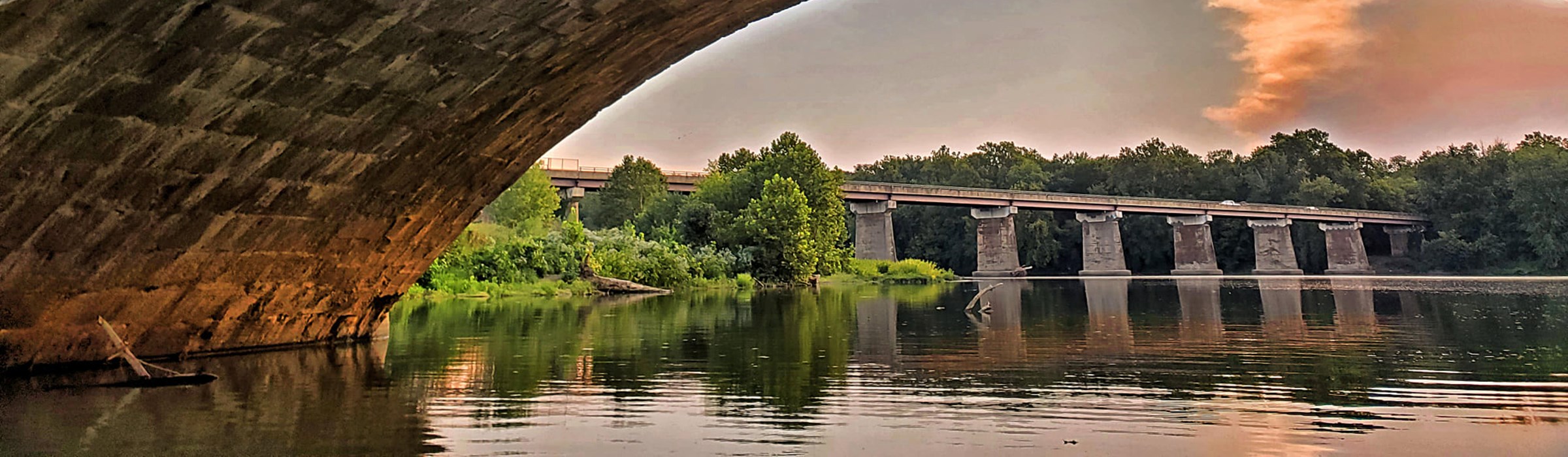 NPS photo | |
The Chesapeake and Ohio Canal began as a dream of passage to western wealth. It operated as a conduit of eastern coal, suffered extensive and finally fatal flooding, and then resisted being paved as a highway. It endures as a national historical park today—a pathway into history nature, and recreation.
A Historic Waterway to the West
To cheers, toasts, and a blaring brass band, President John Quincy Adams broke ground for the Chesapeake and Ohio Canal on Independence Day, 1828. The goal for the canal was ambitious: to improve on nature with a navigable waterway from tidewater at Georgetown to the Ohio River. The people had canal fever and dreamed of a united, wealthy nation trading with the world. A growing nation later saw the dream fulfilled but by other means of transportation.
By the time construction ended in 1850, progress had left the C&O Canal behind and canals were obsolete. Cost overruns, labor problems, and rocky terrain delayed building the canal, but new railroad technology had made great strides. The Baltimore & Ohio Railroad completed the link to the West, while the canal stopped far short of reaching the Ohio River.
In a lifetime canals faded from beacons of a dawning age to quaint reminders of a bygone era. But from 1828 to 1850 thousands of immigrants found work—and hope of new life—building the canal. Until 1924, hundreds of working families would spend their lives along it. In the massive stonework of the locks and the aqueducts, their memories now linger like footprints of a restless nation's great migration westward.
After it closed in 1924 the C&O Canal sat nearly abandoned for 30 years. Flooding and financial ruin killed the C&O Canal Company but not the canal physical remains. Now bypassed by freight and commerce, the canal was soon discovered by people with different goals. The canal's nearly level towpath ran 184.5 miles along the Potomac River. It had survived as a window on the past and a witness to the resilience of nature.
a long stretch of quiet and peace
—Justice William O. Douglas, 1954
One who rediscovered the C&O Canal was U.S. Supreme Court Justice William O. Douglas. Over time, Justice Douglas and other concerned citizens persuaded the federal government to protect the canal. In 1971 Congress established the Chesapeake and Ohio Canal National Historical Park. Now you can enjoy what Douglas called, "a refuge, a place of retreat, a long stretch of quiet and peace."
Hikers, campers, bicyclists, and others can experience the rich history, wildlife, and geology of the Potomac River valley. Watered sections of the canal accommodate canoeists, boaters, and anglers. In Georgetown and Great Falls, Maryland, rangers and volunteers in period clothing take you back to the canal's heyday in the mid-1800s.
Enjoy the Towpath and Canal
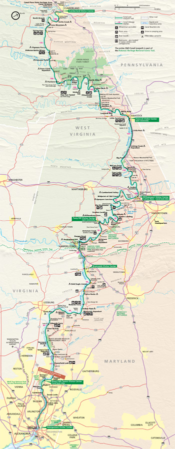 (click for larger map) |
Hiking and Bicycling Brown concrete mileposts occur every mile along the towpath. Bicyclists must observe these regulations: • Do not exceed 15 mph. • Sound your bell or horn as you approach other towpath users. • Ride single-file, staying to the right. • Yield to pedestrians, horses, and mules. • Wear a helmet, as required by law. • Walk bikes across aqueducts.
Camping Camping is permitted only in designated areas. Restrooms and water pumps are at all campgrounds. Potable water is not available in winter. Fires are allowed only in designated areas. • Drive-in camping areas (primitive facilities, no groups) are first-come, first-served. Fees charged. Length-of-stay limits apply. • Group campgrounds require a fee, and Marsden Tract requires a permit you can get at the Great Falls Fee Station. • Hiker-Biker Overnight campsites for tent camping are placed at about five-mile intervals between Mileposts 16.6 and 180.1.
Canoeing and Boating Canoeing and non-motorized boating are possible in the watered canal sections from Georgetown to Milepost 22, and for short stretches above that. NOTE: Canal users must portage (carry their boat or canoe) around each lock. Motorized craft are generally prohibited. Swimming and wading in the canal are prohibited. Fishing is subject to Maryland or Washington, D.C., regulations. Contact visitor center staff about boat rental possibilities.
Hunting, trapping, possessing metal detectors, and relic hunting are prohibited in the park.
For Safety's Sake The Potomac River must be considered extremely dangerous at all times. The river's currents are very strong, deceptive, and unpredictable. Do not swim in the river.
Boat Rides and Visitor Centers
The Chesapeake and Ohio Canal runs along the Potomac River from the mouth of Rock Creek at Georgetown in Washington, D.C., to Cumberland, Md. Its 74 lift locks raised canal boats from near sea level to 605 feet of elevation at Cumberland. The towpath, built 12 feet wide as a path for mules, is now a nearly level byway for hikers and bicyclists to enjoy the canal's quiet beauty. The watered sections afford canoeists, boaters, and anglers quiet waters, while park rangers in period clothing take you back to a time when the canal was alive and well.
Canal Boat Rides Relive life on the canal aboard the park's reproduction canal boats. Enjoy ranger-led programs as you glide along the canal under mulepower. Boat rides depart from Georgetown and Great Falls from April through October. For group reservations, ticket information, and hours of operation, call the Great Falls Tavern Visitor Center.
Visitor Centers
Canal information and history are available at
six park visitor centers and at seasonal contact stations. Hours vary by
season, so please visit www.nps.gov/choh or call for schedules.
Georgetown Visitor Center 1057 Thomas Jefferson Street NW, Washington, D.C. Exhibits on the history of the canal and an urban canal setting.
Great Falls Tavern Visitor Center 11710 MacArthur Blvd., Potomac, Md. Originally a locktender's house, the building was later expanded. Exhibits present the history of the canal and the area.
Brunswick Visitor Center 40 West Potomac Street, Brunswick, Md. Exhibits highlight the town's transportation history from early ferry service to the predominance of the railroad.
Williamsport Visitor Center 205 West Potomac Street, Williamsport, Md. The Cushwa warehouse and basin on the canal are perfect places to delve into this canal town's fascinating history.
Hancock Visitor Center 326 East Main Street, just outside Hancock, Md. Displays tell the story of the canal and explain its operations.
Cumberland Visitor Center Western Maryland Railway Station, 13 Canal Street, Cumberland, Md. Extensive exhibits tell about the canal and its western terminus.
Park rangers and partners open seasonal contact stations at the River Center at Lock 8, Lockhouse 29,Ferry Hill, and Lockhouse 75.
Note: This is a trash-free park. Please take your trash with you when you leave.
Source: NPS Brochure (2011)
|
Establishment
Chesapeake and Ohio Canal National Historical Park — January 8, 1971 |
For More Information Please Visit The  OFFICIAL NPS WEBSITE |
Documents
A Brief History of the C&O Canal National Historical Park (May 25, 1976)
A Chronological Description of the Construction of the Chesapeake and Ohio Canal: 1828-1850 (Harlan D. Unrau, May 1976)
A Preliminary Historical Study on the Area Along the Maryland Shore of the Potomac at Great Falls During the Heyday of the Chesapeake and Ohio Canal, 1858-1880 (Rogers W. Young and T. Sutton Jett, June 1939)
A Study of the History of the Potomac River Valley (Walter S. Sanderlin, 1967)
Allegheny Mound Ants, Formica exsectoides, at Great Falls Park, Maryland (July 14, 1986)
Archeological Excavation at an Historic Dry Lock, Lock 35, C & O Canal- (David J. Meitzer, March 1979)
C & O Canal: The Making of a Park (Barry Mackintosh, 1991)
A Study of the History of the Potomac River Valley (Walter S. Sanderlin, 1967)
Chesapeake and Ohio Canal (1961)
Chesapeake & Ohio Canal National Historical Park Administrative History Update (1991-2021), Washington, D.C., Maryland, and West Virginia (John Bedell, Kate Umlauf and Meredith McCulley, September 30, 2022)
Chesapeake & Ohio Canal Report: House Document No. 687, 81st Congress, 2d Session (August 16, 1950)
Cohongorooto: The Potomac Above the Falls — Archeological Identification and Evaluation Study of C&O Canal National Historical Park, Rock Creek to Sandy Hook (Mile Markers 0 to 59) Volume I (The Louis Berger Group, Inc., December 2005)
Cultural Landscape Report: Ferry Hill, Chesapeake & Ohio Canal National Historical Park (Quinn Evans Architects, June 2004)
Cultural Landscape Report: Fletcher's Cove, Chesapeake & Ohio Canal National Historical Park (Quinn Evans, October 2022)
Cultural Landscape Report: Great Falls Tavern, Chesapeake & Ohio Canal National Historical Park (September 2009)
Cultural Landscapes Inventory: Four Locks, Chesapeake and Ohio Canal National Historical Park (2008)
Cultural Landcapes Inventory: Georgetown Area (August 2018)
Cultural Landscapes Inventory: Seneca Lock, Chesapeake and Ohio Canal National Historical Park (2010)
Development Concept Plan for the Brunswick Maryland Section of Chesapeake and Ohio Canal National Historical Park, Maryland/District of Columbi Draft (April 2024)
Development Concept Plan: White's Ferry Area, Chesapeake & Ohio Canal National Historical Park (March 2023)
"Difficulty on the Chesapeake and Ohio Canal": The Struggles of Black Laborers and Freedom Seekers along the Canal Special History Study: African Americans and the Chesapeake & Ohio Canal from Antebellum to Post-Reconstruction (Sabrina Romain, June 2021)
Digital geologic map and database of the Chesapeake and Ohio Canal National Historical Park and Potomac River corridor, District of Columbia, Virginia, Maryland, and West Virginia USGS Open-File Report 2001-188-A (C. Scott Southworth, David K. Brezinski, Randall C. Orndorff, Peter G. Chirico and Kerry M. Lagueux, 2001)
Enabling Legislation, Chesapeake and Ohio Canal National Historical Park (Public Law 91-664, H.R. 19342, January 8, 1971)
Excursion Boats on the Chesapeake and Ohio Canal (John P. McCarthy, June 2014, rev. August 2014)
Farming Along the Chesapeake and Ohio Canal, 1827-1971: A Study of Agricultural Sites in the C&O Canal National Historical Park (Perry Carpenter Wheelock, August 2007)
Flood-hydrology data for the Potomac River and selected tributaries in the vicinity of the Chesapeake and Ohio Canal National Historical Park, Maryland, West Virginia, and the District of Columbia USGS Open-File Report 97-200 (Edward J. Doheny, 1997)
Foundation Document Overview, Chesapeake and Ohio Canal National Historical Park, District of Columbia/Maryland/West Virginia (August 2013)
General Plan: Chesapeake & Ohio Canal National Historical Park, District of Columbia/Maryland (John G. Parsons, January 30, 1976)
Geologic map of the Potomac River gorge, Great Falls Park, Virginia, and part of the C&O Canal National Historical Park, Maryland USGS Open-File Report 2000-264 (Scott Southworth, ed., Carrie Fingeret and Thomas Weik, 2000)
Geologic Resource Evaluation Report, Antietam National Battlefield, Chesapeake and Ohio Canal National Historical Park, & Harpers Ferry National Historical Park NPS Natural Resource Report NPS/NRPC/GRD/NRR-2005/005 (T.L. Thornberry-Ehrlich, January 2005)
Geology of Great Falls, Maryland (Arthur R. Barwick, 1964)
Geology of the C&O Canal (Calan Bentley, 2006)
Geology of the Chesapeake and Ohio Canal National Historical Park and Potomac River Corridor, District of Columbia, Maryland, West Virginia, and Virginia USGS Professional Paper 1691 (Scott Southworth, David K. Brezinski, Randall C. Orndorff, John E. Repetski and Danielle M. Denenny, 2008)
Georgetown Boundaries & Agreements, Chesapeake & Ohio Canal National Historical Park (September 1984)
Georgetown Waterfront Proposal (January 24, 1987)
Great Falls Rescue Map, Chesapeake & Ohio Canal National Historical Park (August 9, 1974)
Historic Furnishing Report: Lockhouse 44 Chesapeake & Ohio Canal National Historical Park (Mary Grassick, March 2010)
Historic Reconstruction Report: Lock 75, Architectural Data, Chesapeake & Ohio Canal National Historical Park (William Bauman, March 2010)
Historic Resource Study: Brunswick, Maryland — Historical Data (Edward D. Smith, January 1978)
Historic Resource Study: Chesapeake & Ohio Canal (Harlan D. Unrau, August 2007)
Historic Resource Study: Commerce on the C & O Canal, 1830-1924, Chesapeake & Ohio Canal National Historical Park (Harlan D. Unrau, 1976)
Historic Resource Study: Cumberland, Maryland — Historical Data (Edward D. Smith, c1978)
Historic Resource Study: Dam 3 Area: Shenandoah River Lock to Lock 36, Historical Data, Chesapeake & Ohio Canal National Historical Park (Edward D. Smith, December 31, 1979)
Historic Resource Study: Ferry Hill Plantation (Max L. Grivno, August 2007)
Historic Resource Study: Williamsport, Maryland — Historical Data (Edward Smith, July 25, 1979)
Historic Resources Study: African American Communities Along the Chesapeake & Ohio Canal, Washington, D.C., and Lower Montgomery County, Maryland (Heather McMahon, October 27, 2022)
Historic Structure Report: Civilian Conservation Corps (CCC) Structures, Chesapeake & Ohio Canal National Historical Park (CHOH), Potomac, MD (SmithGroup, Gray and Pape, Silman, Building Conservation Associates, Axias, Inc., May 26, 2023)
Historic Structure Report: Dam No. 2 & Associated Structures (Harlan D. Unrau, May 1976)
Historic Structure Report: Dam No. 6 and its Associated Structures (Harlan D. Unrau, December 1974)
Historic Structures Report: Four Locks School (Douglass C. Reed and Paula Stoner Reed, February 1991)
Historic Structure Report: Great Falls Tavern (Beyer Blinder Belle, July 2020)
Historic Structure Report: Guard Lock Number 4, Chesapeake and Ohio Canal, Part I: Historical Data Section (John F. Luzader, undated)
Historic Structure Report: Iron Bridge at Lock #68 — Architectural Data (Thomas E. Fields, October 1976)
Historic Structure Report: Single-Span Aqueducts — Historical Data (Harlan D. Unrau, March 1974)
Historic Structure Report: The Bollman Bridge at Williamsport, Maryland, Historical Data, Chesapeake & Ohio Canal National Historical Park (Harlan D. Unrau, November 1977)
Historic Structure Report: The Canal Prism including Towpath with Canal Berm and River Revetments, Historical Data, Chesapeake and Ohio Canal National Historical Park, MD.-D.C.-VA. (Harlan D. Unrau, October 1974)
Historic Structure Report: The Catoctin Aqueduct — Historical Data (Harlan D. Unrau, March 1976)
Historic Structure Report: The Culverts — Historical Data (Harlan D. Unrau, January 1976)
Historic Structure Report: The Cushwa Warehouse on the Chesapeake & Ohio Canal, Williamsport, Maryland — Historical Data (Harlan D. Unrau, October 1977)
Historic Structure Report: Lock #29 - Lockhouse, Chesapeake and Ohio Canal National Historical Park, Jefferson, Maryland (LeeAnne R. Brooks, October 2023)
Historic Structure Report: The Lockhouses — Historical Data (Harlan D. Unrau, May 1978)
Historic Structure Report: The Masonry Locks (Harlan D. Unrau, June 1978)
Historic Structure Report: The Monocacy Aqueduct — Historical Data (Harlan D. Unrau, January 1976)
Historic Structure Report: The Seneca Aqueduct — Historical Data (Harlan D. Unrau, March 1976)
Historic Structure Report: The Stone House (Misnamed the Salty Dog Saloon) Opposite C & O Canal Lock 33 — Historical Data (Edward D. Smith, March 25, 1980)
Historic Structure Report: Tonoloway Aqueduct, Chesapeake & Ohio National Monument (Edwin C. Bearss, June 30, 1967)
Historic Structures Report: Town Creek Aqueduct (Edwin C. Bearss, February 1966)
Historic Structures Report: Architectural Data Section on the Paw Paw Tunnel — Part I (Archie W. Franzen, March 1965)
Historic Structures Report: Conococheague Aqueduct — Part 1: Historic Data Section (John F. Luzader, 2011)
Historic Structures Report: Survey Report for the Lock #66 Complex Located North of Paw Paw Tunnel — Architectural Data Section (Archie W. Franzen, December 1967)
Historic Structures Report-Part II, Historical Data Section: The Bridges, Chesapeake & Ohio Canal National Monument (Edwin C. Bearss, January 31, 1968)
Historic Structures Report, Historical Data Section: The Composite Locks, Chesapeake & Ohio Canal National Monument (Edwin C. Bearss, March 31, 1968)
Historic Structure Survey: Broad Run Trunk (Edwin M. Dale, John F. Luzader and Charles H. Blake, September 1961)
Historic Structures Survey: The Towpath of the Chesapeake and Ohio Canal (John F. Luzader, 1961)
Historic Structure Survey Report: Tunnel, Chesapeake and Ohio Canal — Part I, Historic Data Section (John F. Luzard, undated)
Impacts of Visitor Spending on the Local Economy: Chesapeake & Ohio Canal National Historical Park, 2003 (Daniel J. Stynes and Ya-Yen Sun, January 2005)
Information Sheets
Abner Cloud House (undated)
Aqueducts (undated)
Boat Interiors (undated)
Buildings in Palisades District on Historic American Buildings Survey (HABS) (February 1986)
Distances Along the Chesapeake and Ohio Canal in Miles (undated)
District Boundary Map (undated)
Flood Damage 2/14 - 2/17/84, C&O Canal National Historical Park (undated)
List of Historic Structures, Georgetown, D.C. to Seneca, Md. (undated)
Locks (undated)
Money circulating along the Canal (undated)
Mules! (undated)
Of Mules and Muskets (undated)
Operation of a Lock (undated)
Palisades District Buildings on State and Local Historic Registers (February 1, 1986)
Palisades District Map (undated)
Parts of the Mule (undated)
Questions & Answers on the C&O Canal (undated)
Presidential John Quincy Adam's Reminiscences of Canal Ground-Breaking Ceremonies, July 4, 1828 (Charles Francis Adams, ed., extract from Memoirs of John Quincy Adams, Vol. 8 1876)
Shawnees Down the South Branch (undated)
Synopsis of History and Legislation of the Chesapeake & Ohio Canal National Historical Park (Rodgers Young and Walter Sanderlin, extract from Great National Project, 1977)
The Chesapeake and Ohio Canal (William Clague, A Collection of Maps of the Chesapeake & Ohio Canal, 1967)
Total Canal Rise and Fall (excerpt from American Canals, November 1979)
Twenty Longest Canals (extract from American Canals, November 1979)
Typical Canal Boat 1850-1924 (undated)
Visitor Use Facilities (undated)
Junior Ranger Activity Book, Chesapeake and Ohio Canal National Historical Park (2010; for reference purposes only)
Junior Ranger Program (Ages 9-12), Chesapeake and Ohio Canal National Historical Park (Date Unknown; for reference purposes only)
Legislation: Cumberland Terminus, Chesapeake and Ohio Canal National Historical Park — J. Glenn Beall, Sr. (Public Law 99-456 [S. 1766], October 8, 1986)
Legislation: Easements, Chesapeake and Ohio Canal National Historical Park (Public Law 184, H.R. 5804, August 1, 1953)
National Register of Historic Places Nomination Forms
C & O Canal (Hazel Grovers Hansrete, May 3, 1971)
Seneca Quarry (Potomac Red Sandstone Quarry, Seneca Stone Company) (Nancy Miller and Michael Bourne, September 26, 1972)
Western Maryland Railway Right-of-Way, Milepost 126 to Milepost 160 (Barry Mackintosh, March 10, 1981)
Natural Resource Condition Assessment, Chesapeake and Ohio Canal National Historical Park, National Capital Region NPS Natural Resource Report NPS/CHOH/NRR-2014/760 (Jane E. Thomas, Simon D. Costanzo, R. Heath Kelsey, Catherine N. Bentsen, William C. Dennison, Patrick Campbell, Mark Lehman, Megan Nortup, Chris Stubbs, Michelle Carter, Brian Carlstrom and John Hitchcock, January 2014)
Newsletter: Great Falls Development Concept Plan (August 28, 2023)
"Our Only Alma Mater": The Civilian Conservation Corps and the C&O Canal Final Draft (Josh Howard, December 16, 2017)
Park Newspaper: June 1980 • Winter 2010/Spring 2011
Potomac River Safety, Multi-Agency Agreement (1985)
Present Reminders of Early Commerce on the Potomac River above Washington (Osgood R. Smith, 1983)
Proclamation 3391, Establishing the Chesapeake and Ohio Canal National Monument, Ohio (January 23, 1961)
River and Mountain, War and Peace — Archeological Identification and Evaluation Study of Chesapeake & OhioCanal National Historical Park, Hancock to Cumberland (Mile Markers 123 to 184) Volume I (The Louis Berger Group, Inc., May 2011)
Spring Flora of the Chesapeake and Ohio Canal Area, Washington, D.C. to Seneca, Maryland (Edward E. Terrell, CASTANEA: The Journal of the Southern Appalachian Botanical Club, Vol. 35 No. 1, March 1970)
Superintendent's Annual Narrative Report: 2001 • 2003
The Bridges, Chesapeake & Ohio Canal (Edwin C. Bearss and Karen M. Gray, January 31, 1961, revised May 24, 2012)
The Chesapeake and Ohio Canal (Samuel Lebowitz, January 14, 1925)
The Flood of '85 (Dick Stanton, December 2, 1985)
The Hassett Farm & Related History (Mike Mastrangelo, undated)
The History of "Four Locks" (Jack Sanderson, undated)
Though the Great Valley and Into the Mountains Beyond — Archeological Identification and Evaluation Study of Chesapeake & Ohio Canal National Historical Park, Sandy Hook to Hancock (Mile Markers 59 to 123) Volume I (The Louis Berger Group, Inc., January 2009)
Trailbike Operations, C&O Canal National Historical Park (March 20, 1984)
Volunteer Handbook, C&O Canal (undated)
"We Are Again In The Midst of Trouble": Flooding on the Potomac River and the Struggle for the Sustainability of the Chesapeake and Ohio Canal, 1828-1996 (Donald R. Shaffer, July 1997)
choh/index.htm
Last Updated: 01-Jan-2025