|
Zion National Park Utah |
|
 NPS photo | |
All this is the music of waters.
—John Wesley Powell, 1895
Wrought by Water
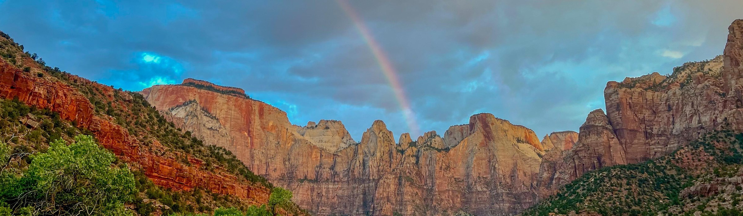
Immutable yet ever changing, the cliffs of Zion stand resolute, a glowing presence in late day, a wild calm. Melodies of waters soothe desert-parched ears, streams twinkle over stone, wren song cascades from redrock cliffs, cottonwood leaves jitter on the breeze. But when lightning flashes waterfalls erupt from dry cliffs, and floods flash down waterless canyons exploding log jams, hurling boulders, croaking wild joyousness, and dancing stone and water and time. Zion is alive with movement, a river of life always here and always changing.
Everything in Zion takes life from the Virgin River's scarce desert waters. Water flows, and solid rock melts into cliffs and towers. Landscape changes as canyons deepen to create forested highlands and lowland deserts. A ribbon of green marks the river's course as diverse plants and animals take shelter and thrive in this canyon oasis. From the beginning people sought this place, this sanctuary in the desert's dry reaches. The very name Zion, meaning "promised land," evokes its significance.
More than the river's music and the soaring heights alone, Zion's nature multiplies with each slope, aspect, and soil type, with each minute change in precipitation or temperature. Add to these influences species from nearby ecosystems, and Zion becomes an assemblage of plants, and thus of animals, found nowhere else exactly like this. Although the southwestern desert may look homogeneous, each fold, wrinkle, bend, slope, mesa top, and canyon bottom creates its unique conditions. This unlikely desert harbors a mosaic of environments, each fine-tuned to place. Welcome to the one called Zion.
Green canyons, red cliffs, blue skies: Zion's colors can stop you in your tracks. Water creates emerald oases of lush plants in an otherwise red desert landscape. Red rocks of a remarkable slot canyon reveal how rushing waters forcefully shaped its narrow and twisting walls. Tinted blue by sky, winter's snow highlights the landscape, and then melts to feed scouring river torrents in spring.
Geologic Contrasts Create Diversity
It's ironic, in this seemingly unending desert, that water creates most of what we see. North of Zion, rain falling on the 11,000-foot-high Colorado Plateau races downhill, slices Zion's relatively soft layers, and pushes its debris off the Plateau's southern edge. This edge is not abrupt, but it steps down in a series of cliffs and slopes known as the Grand Staircase. Above Zion, topping the Staircase, Bryce Canyon's crenellated edges form as water trickles off the Plateau. Below Zion, Grand Canyon forms the lowest rung into which 90 percent of Colorado Plateau waters run. Zion's gathered waters, known as the Virgin River, traverse Mojave Desert lands and join the Colorado River in Lake Mead's handmade basin before completing their Pacific-bound journey.
Long before today's landscape even appeared, streams, oceans, deserts, and volcanos deposited thousands of feet of mud, lime, sand, and ash. The immense pressure and heat of accumulating sediments turned lower layers to stone. Later, underground forces uplifted the Colorado Plateau, 130,000-square-mile mass of rock, over 10,000 feet above sea level. Rain's watery fingers then worked the Plateau's minute cracks, loosening grains and widening fractures—and eroding today's mighty canyons. These processes continue; rivers still deposit sediments that turn to stone, earthquakes still punctuate the Plateau's upward journey, and erosion pries rockfalls from Zion's seemingly immutable cliffs. Eventually, this beautiful canyon will melt away and others will form. All it takes is time.
The Vermilion Cliffs, White Cliffs, and Pink Cliffs are part of the Grand Staircase, the southwestern edge of the Colorado Plateau. The Bryce Canyon and Cedar Breaks amphitheaters are etched into the Pink Cliffs at the top of the Grand Staircase.
Stratigraphy, the study of rock layers, reveals the relative age of the rocks before you at Zion. These rocks formed in environments as varied as sand dunes and shallow sea bottoms.
Navajo sandstone's sweeping lines of contrasting color record the movements of sand dunes.
Kayenta mudstone features dinosaur tracks.
Lower Moenave deposits testify to pooling waters; upper ones indicate swift-moving floods.
Chinle Formation shales are soft and contains petrified wood.
Shinarump Conglomerate is composed of varied sizes of eroded Moenkopi rubble.
The Moenkopi Formation records a shallow sea withdrawing, so the marine fossils differ in its bottom and top layers.
In a Haven of Habitats
People have occupied the landscape of what is now Zion National Park for thousands of years. Zion's first residents tracked mammoths, camels, and other mammals through open desert and sheltered canyons. With climate change, disease, and overhunting, these animals died out 8,000 years ago. Hunters adapted by hunting smaller animals and gathering food. As resources kept diminishing, people adjusted to suit their location. One desert culture, evident here still, evolved over the next 1,500 years as a community of farmers now known as Ancestral Puebloans. The diverse geological setting gave them a combination rare in deserts: terraces to grow food, a river for water, and an adequate growing season. On the Colorado Plateau, crops grow best between 5,000 and 7,000 feet of elevation, which makes Zion's elevations nearly ideal. But drought, resource depletion, and migrations eventually decreased the Ancestral Puebloans' dominance. The Southern Paiute people who followed brought traditions suited to the harsh desert climate and thrived here.
Westward expansion eventually brought new settlers to the canyon. In the 1860s, early Mormon pioneers came to the region and built small communities and farmed the river terraces. Through hard work and faith, the new residents endured in a landscape where flash floods destroyed towns and drought burned crops. The same threats exist today, but Zion daily draws new explorers to experience the beauty and the sanctuary of this place that countless generations have considered home.
Zion's Natural Diversity
The Nature of Sanctuary
Tucked in niches, hidden in soil, peeking from cliffs, or scampering between our feet, an amazing array of plants and animals thrive in Zion National Park. Tiny piñon mice, golden eagles, mountain lions—all thrive in Zion's many habitats. Park elevations range from 3,600 to 8,700 feet and provide vastly different environments. Fir, ponderosa pine, and aspen prefer snowy highcountry winters, while piñon, cliffrose, and mesquite flourish in the desert's heat.
Water, and the lack of it, decides what grows where. On the plateau, above the canyon rim, annual precipitation tops 26 inches. In this relatively cool and moist environment, sego lilies sprout under greenleaf manzanita, yellow-bellied marmots scurry between white fir, and elk mix with an occasional black bear. Here the Virgin River begins in an underground cavern of melted snow.
In the desert over 500 times more species are found at water sources than in the surrounding arid country. The Virgin River's perennial waters give life to an overstory of Fremont cottonwood, singleleaf ash, and boxelder. The rare Zion snail lives only in Zion's isolated hanging gardens that grow lush with maidenhair fern, scarlet monkeyflower, and golden columbine. Canyon treefrogs bleat while campers sleep, and great blue herons wade the river's currents. When summer monsoons send flash floods roaring down canyon, it's a testimony to evolution that anything survives.
That's also true away from the river, where aridity has real meaning. Zion Canyon's annual precipitation may total a mere 15 inches.
At the lowest elevations, Mojave Desert species—desert tortoise and honey mesquite—infiltrate Zion's dry, south-facing canyons. At mid-elevations, Great Basin Desert species like shadscale and big sagebrush mingle with the Colorado Plateau's bigtooth maple and Utah juniper. Zion's biotic diversity is the result of these three communities coming together in one location.
Part of Zion's uniqueness comes from its geology. Great Basin and Mojave Desert soils tend to be similar over great distances. But Zion's stacked prehistoric environments erode into many soils. The Chinle Formation's ancient lakes and volcanic ash, for example, corrode into a soil rich in the poisonous mineral selenium. Specialized plants like prince's plume and milkvetch (also known as locoweed from the effects of its selenium-infused leaves) grow on such odd soils and increase Zion's diversity. Individual and unconnected canyons also increase diversity because isolation can lead to variation among species.
This national park is beautiful but not pristine. Research shows that 150 years of farming, grazing, and recreation changed Zion's environment. Exotic species like tamarisk and cheatgrass replace native willow and native grasses. It is the mission of the National Park Service to provide sanctuary for and reinvigorate Zion's remaining diversity. Although most park species are not unusual and much has changed, these unique assemblages create and sustain the relevance and sanctity of this wondrous place called Zion.
Visiting the Park
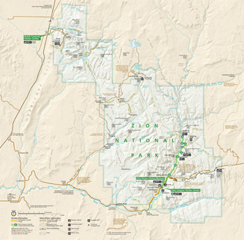 (click for larger map) |
Zion Canyon Visitor Center is open year-round. A 22-minute orientation film is shown regularly at the Zion Human History Museum. Spring through fall, Zion Canyon Scenic Drive is open to shuttle buses only. Check the park website or the park newspapers for dates and times: Map and Guide and Backcountry Planner are available at the entrance gate, visitor centers, and on the park website. Service animals are welcome. For firearms regulations visit the park website or ask a ranger.
Be Prepared, Plan Well, Live Long
• Plan your trip. Choose trails that are within your ability.
• Falls cause most injuries and deaths at Zion.
• Carry and drink one gallon of water per person per day.
• Wear a hat, sunglasses, and sunscreen.
• Avoid or get off high places when lightning threatens.
• Know the weather before you go. Distant storms can cause flash floods.
When in doubt, stay out!
• Cell phones don't work in most areas and don't make you invincible.
• Your safety is your responsibility.
Wilderness
In 2009, Congress protected nearly 84 percent of the park as wilderness under the 1964 Wilderness Act. Wilderness designation protects forever the land's wilderness character, natural conditions, opportunities for solitude, and scientific, educational, and historical values.
Source: NPS Brochure (2011)
|
Establishment
Zion National Park — July 11, 1956 |
For More Information Please Visit The  OFFICIAL NPS WEBSITE |
Documents
Acoustical Monitoring Summary Report: Zion National Park NPS Natural Resource Technical Report NPS/NRPC/NRTR—2011/420 (Katy Warner, January 2011)
All Aboard For Zion (Washington County News, June 23, 1927)
An Overview of the Paleontology of Upper Triassic and Lower Jurassic Rocks in Zion National Park, Utah (Donald D. Deblieux, James I. Kirland, Joshua A. Smith, Jennifer McGuire and Vincent L. Santucci, from New Mexico Museum of Natural History and Science Bulletin No. 37, 2006, ©New Mexico Museum of Natural History and Science, all rights reserved)
Annotated Checklist of Vascular Flora, Zion National Park NPS Natural Resource Technical Report NPS/NCPN/NRTR-2009-157 (Walter Fertig and Jason Alexander, January 2009)
Archeology of Zion Park University of Utah Anthropological Papers No. 22 (Albert H. Schroeder w/Myrl V. Walker, Russell K. Grater, Katharine Bartlett, Irene Emery, Volney H. Jones and Ben W. Wetherill, June 1955)
Bacterial and chemical Inputs to Zion National Park (J. Dain Maddox and George E. Hart, December 1977)
Bighorn Sheep Management Environmental Assessment (August 2017)
Biotic Relationships of Zion Canyon, Utah, with Special Reference to Succession: A Survey of the Geological, Botanical, and Zoological Interrelationships Within a Part of Zion National Park, Utah (Angus M. Woodbury, extract from Ecological Monographs, 3, April 1933)
Birds of Zion, Bryce, and Cedar Breaks Zion-Bryce Museum Bulletin No. 5 (Russell K. Grater, Zion-Bryce Natural History Association, March 1947)
Canyon Transportation System Environmental Assessment, Zion National Park, Utah (November 1995)
Carmel Formation of The Zion Park Region Southwestern Utah—a Review (HTML edition) U.S. Geological Survey Bulletin 1244-J (W.B. Cashion, 1967)
Cultural Landscapes Inventory: Zion Canyon, Zion National Park (2006)
Cultural Landscapes Inventory: Zion Lodge/Birch Creek, Zion National Park (2006)
Ethnographic Overview and Assessment: Zion National Park, Utah and Pipe Spring National Monument, Arizona (Richard W. Stoffle, Diane E. Austin, David B. Halmo and Arthur M. Phillips III, July 1999, revised 2013)
Evaluation of Quality-Control Data and Quality Assurance for Routine Water Quality Monitoring: Bryce Canyon, Capitol Reef, and Zion National Parks, Water Years 2006–2013 NPS Natural Resource Report NPS/NCPN/NRR—2016/1154 (Rebecca H. Weissinger, March 2016)
Final Environmental Statement: Proposed Zion Wilderness, Zion National Park, Utah (1974)
Final General Management Plan/Environmental Impact Statement (Visitor Management and Resource Protection Plan), Zion National Park (January 2001)
Finding Aid: Civilian Conservation Corps (CCC) Reunion 9/28/1989, Zion National Park (January 2008, updated July 2016)
Finding Aid: Pioneer Voices of Zion Canyon, Zion National Park (January 2008, updated July 2016)
First Known Post-Triassic Occurrence of the Palm-like Plant Fossil Sanmiguelia Brown (Sidney Ash, Andrew R.C. Milner, David Sharrow and David Tarailo, extract from Geology of Utah's Far South, Vol. 43, 2014, ©Utah Geological Association)
Food Habits of the Native Fishes in the Virgin River, Zion National Park, Utah (Nancy J. Hoefs, Terrence P. Boyle and James E. Deacon, November 1993)
Foundation Document, Zion National Park, Utah (October 2013)
Foundation Document Overview, Zion National Park, Utah (October 2013)
General Management Plan, Zion National Park (August 2001)
Geologic Map of Zion National Park (Septemer 2005)
Geologic Resource Evaluation Report, Zion National Park NPS Natural Resource Report NPS/NRPC/GRD/NRR-2006/014 (March 2006)
Geomorphic History of the Virgin River in the Zion National Park area, Southwest Utah USGS Open-File Report 95-515 (Richard Hereford, Gordon C. Jacoby and V. Alexander McCord, 1995)
Getting Along: The Significance of Cooperation in the Development of Zion National Park (Wayne K. Hinton, extract from Utah Historical Quarterly, Vol. 68 No. 4, 2000; ©Utah State Historical Society)
Ground-Water Discharge from the Navajo Sandstone to the Streamflow of the Virgin River in the Zion National Park Area NPS Technical Report NPS/NRWRD/NRTR-2005/343 (Paul K. Christensen, Jeffrey C. Hughes and William R. Hansen, November 2005)
Historic American Engineering Record
Zion-Mount Carmel Highway, Virgin River Bridge HAER No. UT-39-C (James Jurale, September 26, 1984)
Zion National Park Historic Trails System, Angels Landing Trail HAER No. UT-40-A (James Jurale, September 14, 1984)
Zion National Park Historic Trails System, Canyon Overlook Trail HAER No. UT-40-B (James Jurale, September 12, 1984)
Zion National Park Historic Trails System, East Rim Trail HAER No. UT-40-C (James Jurale, September 5, 1984)
Zion National Park Historic Trails System, Gateway to the Narrows HAER No. UT-40-D (James Jurale, September 6, 1984)
Zion National Park Historic Trails System, Grotto Trail HAER No. UT-40-E (James Jurale, October 10, 1984)
Zion National Park Historic Trails System, Hidden Canyon Trail HAER No. UT-40-F (James Jurale, October 6, 1984)
Zion National Park Roads and Bridges HAER No. UT-72
History of Zion (A.M. Woodbury, 1937)
Homeland, Homestead, and Haven: The Changing Perspectives of Zion National Park, 1700-1930 (©Sara Suzanne Black, December 2016)
Impacts of Visitor Spending on the Local Economy: Zion National Park, 2006 (Daniel J. Stynes, September 2008)
Including the Present Area of Zion National Monument within Zion National Park, in the State of Utah (House of Representatives Report No. 2306, 84th Congress 2d Session, 1956)
Integrated Upland Monitoring in Zion National Park: Annual Report 2011 (Non-Sensitive Version) NPS Natural Resource Technical Report NPS/NCPN/NRTR—2013/663.N (Dana Witwicki, January 2013)
Invasive Exotic Plant Monitoring in Zion National Park: 2012 Field Season NPS Natural Resource Technical Report NPS/NCPN/NRTR—2013/749 (Dustin Perkins, May 2013)
Invasive Exotic Plant Monitoring in Zion National Park: 2013 Field Season NPS Natural Resource Technical Report NPS/NCPN/NRTR—2014/883 (Dustin W. Perkins, June 2014)
Investigations of Controlled Kolob Reservoir Releases during September 8-17, 1993 at Zion National Park, Utah NPS Technical Report NPS/NRWRD/NRTR-97/108 (Nancy F. Stevens and William R. Hansen, January 1997)
Junior Ranger Handbook (Ages 6-12), Zion National Park (Date Unknown; for reference purposes only)
Kolob Terrace Road Rehabilitation Environmental Assessment, Zion National Park (September 2011)
Land Protection Plan: Zion National Park (1984)
Long-Range Interpretive Plan, Zion National Park (June 2014)
Mammals of Zion-Bryce and Cedar Breaks Zion-Bryce Museum Bulletin No. 2 (C.C. Presnall, Zion-Bryce Natural History Association, January 1938)
Master Plan: Zion National Park, Utah (May 1977)
Master Plan Narrative: Mission 66, Zion National Monument and National Park, Utah (Vols. I & III) (1964)
Mineral resources of eight wilderness study areas bordering Zion National Park, Washington and Kane counties, Utah USGS Bulletin 1746-E (Richard E. Van Loenen, E.G. Sable, H.R. Blank Jr., H.N. Barton, P.H. Briggs, J.E. Zelten and K.L. Cook, 1989)
National Register of Historic Places Nomination Forms
Angels Landing Trail / West Rim Trail (James Jurale, September 4 and 14, 1984)
Cable Creek Bridge (Robert Sontag, July 27, 1995)
Cable Mountain Draw Works (Charles R. Parkinson, January 1972, rev. September 1977)
Canyon Overlook Trail (James Jurale, September 12, 1984)
Crawford Irrigation Canal (James Jurale, October 7, 1984)
East Entrance Checking Station (Nancy Witherell, October 10, 1984)
East Entrance Residence (Nancy Witherall, October 10, 1984)
East Entrance Sign (Nancy Witherall, October 10, 1984)
East Rim Trail (James Jurale, September 5, 1984)
Emerald Pool Trails (James Jurale, September 7, 1984)
Flanigan Ditch (Susan Kardas and Edward Larrabee, 1997)
Floor of the Valley Road (Robert Sontag and Kathy McKoy, August 15, 1995, rev. November 7, 1995)
Gateway To The Narrows Trail (James Jurale, September 6, 1984)
Grotto Picnic Area Comfort Station #129 (Nancy Witherell, October 10, 1984)
Grotto Picnic Area Comfort Station #130 (Nancy Witherell, October 10, 1984)
Grotto Residence (Nancy Witherell, October 10, 1984)
Hidden Canyon Trail (James Jurale, September 6, 1984)
Mattress Shed, Zion Lodge/Birch Creek Historic District (Nancy Witherell, October 10, 1984)
Multiple Resources for Zion National Park (Jim Jurale and Nancy Witherall, 1984)
Multiple Resources for Zion National Park (Listed 1987) (Susan Kardas and Edward Larrabee, March-April 1997)
Oak Creek Irrigation Canal (James Jurale, September 29, 1984)
Oak Creek Historic District Residence (Nancy Witherell, October 10, 1984)
Parunuweap Canyon Archaeological District (Jonathon C. Horn, May 2, 1994)
Pine Creek Irrigation Canal (James Jurale, October 5, 1984)
South Campground Amphitheater (Nancy Witherell, October 10, 1984)
South Campground Comfort Station #131 (Nancy Witherell, October 10, 1984)
South Entrance Sign (Nancy Witherell, October 10, 1984)
Superintendent's Residence, Pine Creek Residential H. D. (James Jurale, July 6, 1984)
Virgin River Bridge (James Jurale, September 26, 1984)
Zion Lodge Historic District (Mary Shivers Culpin, January 12, 1982)
Zion-Mount Carmel Highway (Virgin River Bridge, Pine Creek Bridge, Zion-Mt. Carmel Tunnel) (James Jurale, September 1984)
Zion Nature Center/ Zion Inn (Nancy Witherell, October 10, 1984)
Nature & Nation: The Civilian Conservation Corps in Zion and Bryce Canyon National Parks (©Valerie Lynn Jacobson, Master's Thesis Utah State University, 2017)
Outstandingly Remarkable Values, Virgin Wild and Scenic River, Utah (2012)
Park Newspaper (Map and Guide)
1990: Spring-Summer
1991: Spring-Summer
2001: Summer
2003: Summer
2009: Spring • Summer • Fall • Winter • Centennial Edition
2010: Spring • Summer • Fall • Winter
2011: Spring • Summer • Fall • Winter
2012: Spring • Summer • Fall • Winter
2013: Spring • Summer • Fall • Winter
2014: Spring • Summer • Fall • Winter
2015: Spring • Summer • Fall • Winter
2016: Spring • Summer • Fall • Winter
2017: Spring • Summer • Fall/Winter • Winter
2018: Spring • Summer • Fall • Winter
2019: Spring • Summer • Fall Winter
2020: Spring • May 13-21 • Beginning May 22 • Beginning July 1 • August 5 • October 13 • Winter
2021: Spring • Summer • Fall/Winter
2022: Winter • Summer • Fall/Winter • Winter
2023: Spring • Fall/Winter
2024: Spring • Summer • Fall/Winter
French: 2009 • 2014 • German: 2009 • 2013 • Italian: 2012 • Spanish: 2010
Preliminary Hydrological Assessment of Grapevine Spring, Zion National Park, and a Comparison with Other Springs in the Park (Wayne L. Hamilton, January 10, 1975)
Regional Frequency Analysis of Peak Flows at Zion National Park and Vicinity Areas, Utah (Gustavo E. Diaz and Jose D. Salas, May 1994)
Report on Preliminary Reconnaissance for the Development of Zion National Park, Utah, Region Three (Paul R. Franke, Glenn O. Hendrix and Carl W. Alleman, July 15, 1955)
Report on Sullys Hill Park, Casa Grande Ruin; the Muir Woods, Petrified Forest, and Other National Monuments, Including List of Bird Reserves: 1915 (HTML edition) (Secretary of the Interior, 1914)
Report on Wind Cave National Park, Sullys Hill Park, Casa Grande Ruin, Muir Woods, Petrified Forest, and Other National Monuments, Including List of Bird Reserves: 1913 (HTML edition) (Secretary of the Interior, 1914)
Research to Support Application of the Visitor Experience and Resource Protection Framework at Zion National Park (Robert Manning, Wayne Freimund and Jeffrey Marion, Date Unknown)
Resource Brief: Birds and Climate Change, Zion National Park (2018)
Riparian Monitoring of Wadeable Streams, East Fork Virgin River, Zion National Park: Summary Report, 2008–2012 NPS Natural Resource Report NPS/NCPN/NRR—2015/1021 (Dana L. Witwicki and Rebecca Weissinger, September 2015)
Riparian Vegetation Along Two Forks of the Virgin River in Zion National Park, Utah (Dean Wm. Taylor, December 1989)
Riparian Vegetation Study: Zion National Park, Utah (BioSystems Analysis, Inc., September 8, 1988)
Route 10 Zion-Mt. Carmel Highway Tunnel Area Road Rehabilitation Environmental Assessment/Assessment of Effect, Zion National Park (February 2006)
Self-evaluation of Policies and Practices and Evaluation for Non-discrimination in Park Programs, Services and Activities: Zion National Park (September 30, 2016)
Settlement for Bryce Park Road Trouble is Near (Washington County News, July 14, 1927)
Sharing the Canyon: Accommodating Bicyclists on the Zion Canyon Scenic Drive (Jeff De Bellis, Summer 2007)
State of the Park Report, Zion National Park, Utah State of the Park Series No. 23 (2016)
Soundscape Management Plan and Environmental Assessment, Zion National Park, Utah (August 2010)
Special Report on Status Desert Bighorn in Zion National Park (Joseph S. Dixon, October 27, 1938)
Special Report on the Deer Problem in Zion National Park (E. Lowell Sumner, Jr., December 11, 1937)
Special Report: Plant & Animal Life in Zion National Park (W.B. McDougall, May 1940)
Special Report: The Deer Problem in Zion National Park (W.B. McDougall, October 1941)
Spring Discharge at Cedar Breaks National Monument and Zion National Park, Southwestern Utah Administrative Report (C.T. Sumsion, 1971)
Statement for Management — Zion National Park (June 1987)
Stochastic Modeling and Daily-Flows Generation at the North Fork of the Virgin River above Narrow Canyon, Zion National Park, Utah (Gustavo E. Diaz, February 1993)
Streamflow Characterization at Zion National Park, Utah (Gustavo E. Diaz, August 1992)
The Algal Flora of Selected Wet Walls in Zion National Park, Utah, USA (Jeffrey R. Johansen, Samuel R. Rushforth, Reed Orbendorfer, Natha Fungladda and Judith A. Grimes, extract from Nova Hedwigia, Vol. 38, January 1983)
The Changing Face of the East Mojave Desert: Abstracts from the 2001 Desert Symposium (Robert E. Reynolds, ed., April 2001)
The Land That God Forgot (Juanita Brooks, extract from Utah Historical Quarterly, Vol. 26 No. 3, 1958; ©Utah State Historical Society)
The oldest known Early Triassic fossil vertebrate footprints in North America, from Zion National Park, Utah (Debra L. Mickelson, Andrew R.C. Milner, Donald D. DeBlieux and Jenny L. McGuire, New Mexico Museum of Natural History & Science Bulletin 34, 2006, ©New Mexico Museum of Natural History and Science, all rights reserved)
The Road Inventory of Zion National Park (April 2000)
Trees of Zion and Bryce Canyon National Parks (1960)
Unstable Slope Assessment Report: Phase II Conceptual Design, Priority Slope Locations, Zion National Park Department of Transportation Geotechnical Report No. UT-NX-USMP-20-01 (November 2020)
Vascular Plant Species Discoveries in the Northern Colorado Plateau Network: Update for 2008-2011 NPS Natural Resource Technical Report NPS/NCPN/NRTR-2012/582 (Walter Fertig, Sarah Topp, Mary Moran, Terri Hildebrand, Jeff Ott and Derrick Zobell, May 2012)
Wilderness Guide/Backcountry Planner: 2001 • 2005 • 2006 • 2007 • 2008 • 2009 • 2010 • 2012 • 2015 • 2016 • 2017 • 2018 • 2019 • 2021
Zion-Bryce Nature Notes (1929-1936, 2009-2011)
Zion Canyon South Entrance Redesign (PEPC 104914) Environmental Assessment (March 2024)
Zion Canyon Transportation System Technical Analysis — Executive Summary (September 2009)
Zion Deer (Joseph S. Dixon, October 27, 1938)
Zion National Monument (United States Railroad Administration, 1919)
Zion National Park: A Geologic and Geographic Sketch (HTML edition) Zion-Bryce Museum Bulletin No. 3 (Zion-Bryce Natural History Association, January 1947)
Zion National Park Forever Project Field Guides: 2020 • 2021 • 2022 • 2023 • 2024 (Zion National Park Forever Project)
Zion National Park With Some Reminiscences Fifty Years Later (A. Karl Larson, extract from Utah Historical Quarterly, Vol. 37 No. 4, 1969; ©Utah State Historical Society)
Zion-Mt. Carmel Highway Rehabilitation Environmental Assessment/Assessment of Effect, Zion National Park (June 2009)
zion/index.htm
Last Updated: 24-Jan-2025