|
Grand Canyon National Park Arizona |
|
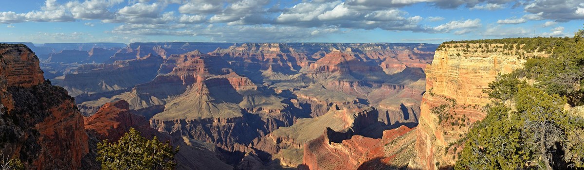 NPS photo | |
In time and with water, everything changes.
—Leonardo da Vinci
Adapting to Change
Ancient people hunted and foraged throughout Grand Canyon. They might have entered and left by some of the same trailheads in use today. Seasons, and perhaps tradition, guided their forays. Shifts in climate might have caused the extinction of some plants and prey important in their diet and material culture—but they weathered these and other changes by adapting. Totemic split-twig figurines tucked away in dry caves, masonry structures, images drawn and etched into rock, and objects placed at the upper reaches of pinnacles show that the canyon sheltered, fed, and inspired people for millennia. The grand scale of the place and a gulf of time—600 generations deep—separate the early people of the canyon from us.
Hunters
A broken spear point tells us that a hunter passed through Marble
Canyon, at the park's northeastern edge, about 11,000 years BP (Before
Present). Some tribes associated with the canyon may be descendants of
this hunter, who possibly used his spear to bring down now extinct large
mammals such as mammoth and smaller game like deer and bighorn sheep.
The broken point is one of the few artifacts found inside the park made
by Paleo-Indians. (The earliest human inhabitants of North America, they
probably came across a land bridge from Asia during the last ice
age.)
Foragers
The river could have been a touchstone for Grand Canyon's Paleo-Indians
(from 12,000 BP) and Archaic peoples (from 9,000 BP). It provided
drinking water and conditions where useful plants like willow, amaranth,
mesquite, and salt bush could grow. (You may see many other species here
today that are modern invaders.) Some Archaic and Basketmaker (from
2,000 BP) peoples from the uplands could have taken refuge in the
canyon, close to the river, when the climate became warmer and drier.
Dwellers
Throughout the 277-mile (455-kilometer) river corridor inside the park,
people built masonry rooms, hearths, and pits for roasting food or
perhaps firing pottery (the earliest pottery found in Grand Canyon dates
from about 1,500 BP, when Puebloan people farmed along the canyon rims
and deltas). The combination of masonry rooms, pottery, tools, and
hearths shows that some people rot only hunted and foraged, but also
lived full lives here.
Eleven traditionally associated tribes—Yavapai-Apache, Havasupai, Hopi, Hualapai, Kaibab Paiute, Las Vegas Paiute, Moapa Paiute, Navajo, Paiute Indian, San Juan Southern Paiute, and Zuni—continue to live in or use the canyon for trade, to collect plants, minerals, and other traditional materials, and for ceremonial purposes.
Uncovering Human History
From 2006 to 2009, people of several tribes traditionally associated
with Grand Canyon worked with park staff and the Museum of Northern
Arizona on several excavations in the park. Although most tribes oppose
any disturbance of their heritage, circumstances justified the Grand
Archaeology project. The erosion of sediments in the river corridor had
uncovered long-buried artifacts and structures, exposing them to damage
by weather, and other dangers.
Through their traditional knowledge, tribal people enriched the project. They helped identify meanings and uses of artifacts, and discovered links with their ancestors.
How can understanding and preserving these artifacts have value for all of us?
Grand Canyon National Park preserves and protects wildlife, natural systems, and cultural resources for future generations.
A Canyon Carved by Water
The hunter's spear came to rest in a sublime, vertical landscape. Its broken point was found halfway between the rim, where the canyon walls meet the surrounding plateau, and the bottom, where the Colorado River now runs.
Six million years earlier, the river and its tributaries began to carve downward through the plateau.
Making Geological History
The story of Grand Canyon's formation is much deeper than six million
years, and is still continuing. Since 65 million years ago, the entire
Rocky Mountain-Colorado Plateau region has been rising. Immediately
below the plateau's crust are the same sedimentary rocks you can see in
the canyon's walls—sandstone, limestone, and shale. Shallow seas
and changing rivers deposited the sediments over nearly two billion
years.
The Colorado and its tributary rivers flowed across and cut into the plateau, revealing flat-lying, multicolored rocks formed in the Paleozoic era (about 541 to 252 million years BP). These layers, visible from both North and South rims, contain marine fossils that record some of Earth's earliest life forms.
Below the Paleozoic rocks are the tilted layers of the Grand Canyon Supergroup, which formed about one billion years BP. You can see them from Desert View Drive and at the Yavapai Geology Museum.
Below the Supergroup, at the canyon bottom, the river cut through some of the plateau's oldest, or "basement," rocks, formed as much as 1.84 billion years BP.
Water in the Rocks
Precipitation falling on the Coconino (South Rim) and Kaibab (North Rim)
plateaus becomes Grand Canyon's groundwater. It percolates through
porous, faulted, or fractured rock. Some water exits from the canyon
walls, far below the rims, as springs or seeps. Roaring Springs is one
of Grand Canyon's 700 seasonal and perennial seeps and springs. It
emerges from a limestone cave 3,500 feet (1,067 meters) below the North
Rim in eastern Grand Canyon. A pipeline built in the 1960s travels
through Phantom Ranch at the canyon bottom before it reaches the South
Rim. It is the only local source of drinking water for both rims and the
inner canyon. Breaks and repairs sometimes interrupt water delivery.
From Rim to River
Before you are waves of stair-stepped ledges, cliffs, and buttes painted ochre, green, and gray. Within moments the colors deepen, then brighten as clouds drift past. You marvel at the slender, shimmering ribbon of river that, along with erosion, carved through rock layers to create this natural wonder. Side canyons branch in all directions from the river.
Behind you—at the South Rim—are roads, signs, sidewalks and trails, hotels, visitor centers, museums, campgrounds, offices, concessioners, a rail depot, buses, cars, and bicycles. At the North Rim you'll find fewer human-made distractions. Use the free pocket maps to locate visitor services and see how to get around both rims.
North Rim
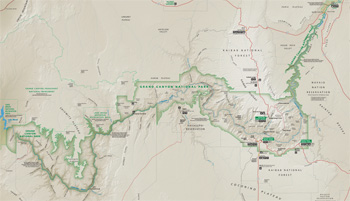    (click for larger maps) |
With a higher elevation (8,000 feet, or 2,438 meters) and more precipitation than the South Rim, temperatures are cooler and forests thicker. The southward tilt of the land directs water to side canyons where sharp, narrow landforms result from the increased erosion.
On your approach through the Kaibab Plateau, you'll pass through some fire-blackened, wooded areas. After people began to suppress fires in the 1900s, dense undergrowth accumulated and became added fuel. Although native ponderosa pines and other species are adapted to withstand lower-temperature fires, many trees succumbed when fires began to burn hotter and longer. Now the forest composition is changing as more aspen and subalpine trees, like Engelmann spruce, fill in former areas of mixed conifers.
From the visitor center, take a short walk to Bright Angel Point for views of Bright Angel Canyon and Roaring Springs, the main source for drinking water in Grand Canyon. Drive north to Point Imperial where you can see the Vermilion Cliffs and Marble Canyon to the east. From here, drive south to Cape Royal for a panoramic view of the Unkar Delta, farmed by ancestral Puebloans, and the Colorado River.
South Rim
Pinyon and juniper trees survive with less than 15 inches (38 centimeters) of rainfall annually at this elevation (7,000 feet, or 2,133 meters). Both trees have tiny leaves to minimize the surface area exposed to the dry air. Yucca's thick, waxy leaves conserve the moisture that their muscular roots pull from the South Rim's dry, rocky soil. Cliffrose and Gambel oak hug the rim. As you move away from the rim the soil's moisture and nutrient levels improve, and ponderosa pines grow in stands.
From Mather Point, gaze across and downward. You'll see tiny patches of bright green in the canyon bottom. The spots of color mark springs at Phantom Ranch and Bright Angel Campground, stopping points for many who make the rim-to-rim trek.
A rimside walk of less than one mile (1.61 kilometers) will take you from Mather Point to Yavapai Point. On cold or rainy days, study the canyon's rock layers from the geology museum's picture windows.
It's 25 miles (7.62 kilometers) by car from Grand Canyon Village to Desert View. Consider a stop at the Tusayan Museum and Ruin. Pull-outs offer broad views of the Painted Desert and the river.
The River's Course
The Colorado River begins as a trickle of meltwater high in northern Colorado's Never Summer Mountains. Streams and tributary rivers increase its size and volume until it reaches Lake Powell, created by Glen Canyon Dam (completed 1963). The lake traps most sediment carried by the river, so the water released from the dam base is clearer. It is also colder. Grand Canyon's native fish are adapted to more sediment and warmer water. As the result, they cannot thrive today.
Where the River Exits the Park
Near the park's western edge the Colorado River flows through the Grand Wash Cliffs. Here the Hoover Dam (completed 1935) impounds the river to create Lake Mead. Water from the lake is used for recreation and is also sent to major cities, small communities, and agricultural areas throughout California, Nevada, and Arizona. As human use of water grows throughout the Southwest, can one river meet the increased demand?
Safety and Regulations
Stay on trails and away from cliffs. • Thunderstorms are common in summer. In the event of lightning, seek shelter and stay away from the rim and exposed areas. • It is illegal to launch, land, or operate unmanned aircraft inside Grand Canyon National Park. • Pets must be leashed. Refer to the pocket maps for restrictions and information. • Motor vehicles, including mountain bikes, are restricted to maintained roads. The map above does not show roads. Use pocket maps for road and trail information. • When hiking, carry food and water. Wear sun protection and appropriate clothing and shoes. Do not try to hike to the river and back in one day; it is dangerous. • It is illegal to feed deer, squirrels, or other park wildlife. • For firearms regulations check the park website.
Accessibility
We strive to make our facilities, services, and programs accessible to
all. Call or check our website.
Emergencies call 911
Source: NPS Brochure (2019)
|
Establishment
World Heritage Site — October 26, 1979 |
For More Information Please Visit The  OFFICIAL NPS WEBSITE |
Documents
100 Years, One Million Lives, One Grand Canyon (2019)
2019 Paleontology After Action Report, Grand Canyon National Park (Diana M. Boudreau, November 2019)
A Cross Section of Grand Canyon Archeology: Excavations at Five Sites Along the Colorado River Western Archeological and Conservation Center Publications in Anthropology No. 28 (Anne Trinkle Jones, April 1986)
A General Index to Grand Canyon Nature Notes, 1926-1935 (Hazel Hunt Voth, 1938)
A Guide to Grand Canyon Village Historic District (Timothy Manns, undated)
A History of National Park Service Interpretation at Grand Canyon National Park (©Sarah Ruth Gerke, Master's Thesis Arizona State University, December 2010)
A New Erosion Cycle in the Grand Canyon District, Arizona (H.H. Robinson, extract from The Journal of Geology, Vol. 18 No. 8, November-December 1910)
A Plan for the Development of the Village of Grand Canyon, Ariz. (Frank A. Waugh, 1918)
Accomplishment Report, Fiscal Year 2009/2010, Grand Canyon National Park (c2010)
Acoustic Monitoring Report: 2017, Grand Canyon National Park NPS Natural Resource Report NPS/NRSS/NSNSD/NRR-2020/2070 (Jacob Job, February 2020)
Adjacent Lands Study, Grand Canyon National Park, Arizona Final (November 1981)
Adjacent Lands Study, Grand Canyon National Park, Arizona Public Review Draft (March 1981)
Aggradation and degradation of alluvial sand deposits, 1965 to 1986, Colorado River, Grand Canyon National Park, Arizona; executive summary USGS Open-File Report 87-561 (J.C. Schmidt and J.B. Graf, 1988)
Aggradation and degradation of alluvial sand deposits, 1965 to 1986, Colorado River, Grand Canyon National Park, Arizona USGS Open-File Report 87-555 (J.C. Schmidt and J.B. Graf, 1988)
Aggradation and degradation of alluvial sand deposits, 1965 to 1986, Colorado River, Grand Canyon National Park, Arizona USGS Professional Paper 1493 (John C. Schmidt and Julia B. Graf, 1990)
Algonkian Rocks of the Grand Canyon of the Colorado (Charles D. Walcott, extract from The Journal of Geology, Vol. 3 No. 3, April-May 1895)
Among the Birds in the Grand Canyon Country (Florence Merriam Bailey, 1939)
An Interview with the Great Unconformity: Howie Usher, Scientist and River Guide (Howie Usher, Amy Ilona Stein and Byron E. Pearson, extract from Journal of Arizona History, Vol. 60 No. 4, Winter 2019)
An Inventory of Paleontological Resources Associated with Caves in Grand Canyon National Park (Jason Kenworthy, Vincent L. Santucci and Kenneth L. Cole, extract from The Colorado Plateau: Cultural, Biological, and Physical Research, C. van Riper III, and K.L. Cole (eds.), 2004)
An Unusual Tetrapod Track Morphology from the Permian Coconino Sandstone, Grand Canyon National Park, Arizona (Adrian P. Hunt and Vincent L. Santucci, extract from Proceedings of the 6th Fossil Resource Conference, September 2001)
Anthropogenic influence on groundwater geochemistry in Horn Creek Watershed near the Orphan Mine in Grand Canyon National Park, Arizona, USA (Kimberly R. Beisner, Collin Davidson and Fred Tillman, extract from Geochemistry: Exploration, Environment, Analysis, Vo. 23, 2023)
Application Guidelines for Research and Collecting Permits (August 2000)
Archaeological sites in Grand Canyon National Park along the Colorado River are eroding owing to six decades of Glen Canyon Dam operations (Joel B. Sankey, Amy East, Helen C. Fairley, Joshua Caster, Jennifer Dierker, Ellen Brennan, Lonnie Pilkington, Nathaniel Bransky and Alan Kasprak, extract from Journal of Environmental Management, Vol. 342, May 12, 2023)
Archaeological Survey of Walhalla Glades Museum of Northern Arizona Bulletin 20 (E.T. Hall, Jr., June 1942)
Architectural Character Guidelines: Grand Canyon National Park (September 1994)
Assessment of Spring Chemistry Along the South Rim of Grand Canyon in Grand Canyon National Park, Arizona USGS Fact Sheet 2005-3006 (Robert J. Hart, John Rihs, Howard E. Taylor and Stephen A. Monroe, 2002)
Aspects of the Virgin Anasazi Tradition in Grand Canyon (Robert C. Euler, extract from Utah Archaeology, Vol. 7 No. 1, 1994, ©Utah Statewide Archaeological Society and the Utah Professional Archaeological Council)
Authorities for Water Resources Decision Making on the Colorado River Draft (April 1991)
Backcountry and River Use Statistics: 2017 • 2018 • 2019 • 2020 • 2021 • 2023 • 2022 • 2024 (Steve Sullivan)
Backcountry Statistics: 2009 • 2015 • 2016 (Steve Sullivan)
Bibliography of Colorado Plateau Region (undated)
Bibliography of Paleontology of the Grand Canyon Region and in the Stratigraphic Continuity of Grand Canyon Formations (Earle E. Spamer, extract from The Grand Canyon: A Worldwide Bibliography of the Grand Canyon and Lower Colorado River Regions in the United States and Mexico, 2019)
Biological and Hydrological Surveys of Springs Along the Colorado River, Utah and Arizona: Surveys of Springs in the Colorado River Drainage in Arches National Park, Canyonlands National Park, Glen Canyon National Recreation Area, and Grand Canyon National Park — Part I Final Report (John R. Spence, February 2004)
Biological and Hydrological Surveys of Springs Along the Colorado River, Utah and Arizona: Surveys of Springs in the Colorado River Drainage in Arches National Park, Canyonlands National Park, Glen Canyon National Recreation Area, and Grand Canyon National Park — Part II - Appendices (A1-A5) Final Report (John R. Spence, February 2004)
Biological and Hydrological Surveys of Springs Along the Colorado River, Utah and Arizona: Surveys of Springs in the Colorado River Drainage in Arches National Park, Canyonlands National Park, Glen Canyon National Recreation Area, and Grand Canyon National Park — Part II - Appendices (A6) Final Report (John R. Spence, February 2004)
Biological and Hydrological Surveys of Springs Along the Colorado River, Utah and Arizona: Surveys of Springs in the Colorado River Drainage in Arches National Park, Canyonlands National Park, Glen Canyon National Recreation Area, and Grand Canyon National Park — Part II - Appendices (A7-A9) Final Report (John R. Spence, February 2004)
Boy Scouts at the Grand Canyon (Walter Prichard Eaton, 1932)
Bird Community Monitoring for Grand Canyon National Park: 2007 Summary Report NPS Natural Resource Data Series NPS/SCPN/NRDS—2010/099 (Jennifer A. Holmes and Matthew J. Johnson, November 2010)
Bird Community Monitoring for Grand Canyon National Park: 2011 Summary Report NPS Natural Resource Data Series NPS/SCPN/NRDS—2013/465 (Jennifer A. Holmes and Matthew J. Johnson, April 2013)
Bird Community Monitoring for Grand Canyon National Park: 2014 Summary Report NPS Natural Resource Report NPS/SCPN/NRDS—2016/1033 (Jennifer A. Holmes and Matthew J. Johnson, June 2016)
Briefing Paper: Project MOHAVE (July 15, 1997)
Briefing Paper: Western Visibility and Air Partnership (July 15, 1997)
Capacity Analysis/Water Management Alternatives, South Rim Developed Area, Grand Canyon National Park, Arizona (April 1978)
Carboniferous chondrichthyan assemblages from the Surprise Canyon and Watahomigi formations (latest Mississippian–Early Pennsylvanian) of the western Grand Canyon, Northern Arizona (John-Paul M. Hodnett and David K. Elliott, extract from Journal of Paleontology, Vol. 92 Memoir 77, 2018, ©The Paleontological Society)
Centennial Paleontological Resource Inventory (Non-Sensitive Version), Grand Canyon National Park NPS Natural Resource Report NPS/GRCA/NRR-2020/2103 (Vincent L. Santucci and Justin S. Tweet, eds., March 2020)
Chemical characteristics of ground-water discharge along the south rim of Grand Canyon in Grand Canyon National Park, Arizona, 2000-2001 USGS Scientific Investigations Report 2004-5146 (Stephen A. Monroe, Ronald C. Antweiler, Robert J. Hart, Howard E. Taylor, Margot Truini, John R. Rihs and Tracey J. Felger, 2005)
Colorado River Management Plan, Grand Canyon National Park, Arizona Draft (October 1977)
Colorado River Management Plan, Grand Canyon National Park, Arizona (1979)
Colorado River Management Plan, Grand Canyon National Park, Arizona Draft (November 1988)
Colorado River Management Plan, Grand Canyon National Park, Arizona (2006)
Colorado River Management Plan and Annual Operating Requirements, Grand Canyon National Park, Arizona (December 1981)
Colorado River Research Program Report Series
1. Design and Method of the Sociological Research in the Grand Canyon Colorado River Research Program Technical Report No. 1 (Bo Shelby and Joyce M. Nielsen, June 1976)
2. Motors and Oars in the Grand Canyon Colorado River Research Program Technical Report No. 2 (Bo Shelby and Joyce M. Nielsen, June 1976)
3. Use Levels and Crowding in the Grand Canyon Colorado River Research Program Technical Report No. 3 (Bo Shelby and Joyce M. Nielsen, June 1976)
4. Private and Commercial Trips in the Grand Canyon Colorado River Research Program Technical Report No. 4 (Bo Shelby and Joyce M. Nielsen, June 1976)
10. An Ecological Survey of the Riparian Zone of the Colorado River Between Lees Ferry and Grand Wash Cliffs Colorado River Research Program Technical Report No. 10 (Steven W. Carothers, et al., June 1976)
12. Survey of Bacteria, Phytoplankton and Trace Chemistry of the Lower Colorado River and Tributaries in the Grand Canyon National Park Colorado River Research Program Technical Report No. 12 (Milton R. Sommerfield, Wayne M. Crayton and Nancy L. Crane, July 15, 1976)
16. An Economic Analysis of the River Running Industry in the Grand Canyon National Park Colorado River Research Program Technical Report No. 16 (C.R. Michael Parent and F.E. Robeson, December 13, 1976)
17. Synthesis and Management Implications of the Colorado River Research Program Colorado River Research Program Technical Report No. 17 (R. Roy Johnson, September 1977)
18. Sound-Level Evaluations of Motor Noise from Pontoon Rafts in the Grand Canyon Colorado River Research Program Technical Report No. 18 (D.N. Thompson, A.J. Rogers, Jr. and F.Y. Borden, 1974)
Colorado River Sand Budge: Lees Ferry to Little Colorado River NPS Technical Report NPS/NRWRD/NRTR-92/12 (Gary M. Smilie, William L. Jackson and Dean Tucker, May 1993)
Continuity and Parkitecture: The Lookout of the Grand Canyon (Linda Reeder, extract from 2019 Architecture, Culture, and Spirituality Symposium (ACS11), 2019)
Cooperative National Park Resources Study Unit — Arizona
4. Improving Visitor Communications in Grand Canyon National Park Cooperative National Park Resources Studies Unit Technical Report No. 4 (Laura B. Greenburg and A. Heaton Underhill, March 1986)
9. Vegetation of Grand Canyon National Park Cooperative National Park Resources Studies Unit Technical Report No. 9 (Peter L. Warren, Karen L. Reichhardt, David A. Mouat, Bryan T. Brown and R. Roy Johnson, August 1982)
12. International Visitors to Grand Canyon National Park Cooperative National Park Resources Studies Unit Technical Report No. 12 (A. Heaton Underhill and Amy H. Fonken, May 1983)
14. Grand Canyon National Park Visitors Cooperative National Park Resources Studies Unit Technical Report No. 14 (A. Heaton Underhill, July 1984)
25. Breeding Ecology of Riparian Birds Along the Colorado River in Grand Canyon, Arizona Cooperative National Park Resources Studies Unit Technical Report No. 25 (Bryan Turner Brown, June 1989)
Status and Nesting Habitat Requirements of Bell's Vireo Along the Colorado River in Grand Canyon National Park, Arizona: A Preliminary Report Cooperative National Park Resources Studies Unit Technical Report (Bryan T. Brown and R. Roy Johnson, November 1982)
Cultural Artifact and Work of Art: Grand Canyon Landscape Painting (Amy Ilona Stein, extract from Journal of Arizona History, Vol. 60 No. 4, Winter 2019)
Cultural Landscape Inventory: Cross Canyon Corridor Historic District, Grand Canyon National Park (April 2013)
Cultural Landscape Inventory and Treatment Recommendations: Desert View (John Milner Associates, 2004)
Cultural Landscape Report: Grand Canyon Village National Historic Landmark District (January 2004)
Cultural Landscape Report: Indian Garden, Grand Canyon National Park (John Milner Associates, Inc., June 2005)
Cultural Landscapes Inventory: West Rim Drive, Grand Canyon National Park (2005)
Dating prehistoric tributary debris fans, Colorado River, Grand Canyon National Park, Arizona with implications for channel evolution and river navigability USGS Open-File Report 97-167 (Robert H. Webb, T.S. Melis, P.G. Griffiths and J.G. Elliott, 1997)
Debris flows from tributaries of the Colorado River, Grand Canyon National Park, Arizona; executive summary USGS Open-File Report 87-117 (R.H. Webb, 1987)
Development Concept: Grand Canyon Village, Grand Canyon National Park, Arizona (May 1977)
Debris flows from tributaries of the Colorado River, Grand Canyon National Park, Arizona USGS Professional Paper 1492 (Robert H. Webb, Patrick T. Pringle, and Glenn R. Rink, 1989)
Draft General Management Plan/Environmental Impact Statement, Grand Canyon National Park, Arizona (March 1995)
Early adaptation to eolian sand dunes by basal amniotes is documented in two Pennsylvanian Grand Canyon trackways (Stephen M. Rowland, Mario V. Caputo and Zachary A. Jensen, extract from PLOS ONE, August 19, 2020)
Economic Impacts of Grand Canyon National Park Visitor Spending on the Local Economy, 2003 (Daniel J. Stynes and Ya-Yen Sun, January 2005)
Effects of Recent Flooding on Riparian Plant Establishment in Grand Canyon (Gwendolyn L. Waring and Lawrence E. Stevens, November 11, 1986)
Effects of Varied Flow Regimes on Aquatic Resources of Glen and Grand Canyons Final Report (Henry R. Maddux, Dennis M. Kubly, James C. deVos, Jr., William R. Persons, Richard Staedicke and Rebecca L. Wright, May 1987)
Eighty Pounds of Bronze — Grand Canyon's Memorial Mather Plaques (G. Arthur Janssen, from The Ol' Pioneer: The Magazine of the Grand Canyon Historical Society, Vol. 26 No. 4, Fall 2015, ©Grand Canyon Historical Society)
Environmental History: The View at the Grand Canyon (Donald Worster, undated)
Evaluation of Airborne Image Data for Mapping Riparian Vegetation within the Grand Canyon USGS Open-File Report 2002-470 (Philip A. Davis, Matthew I. Staid, Jeffrey B. Plescia and Jeffrey R. Johnson, 2002)
Evaluation of Airborne Thermal-Infrared Image Data for Monitoring Aquatic Habitats and Cultural Resources within the Grand Canyon USGS Open-File Report 2002-367 (Philip A. Davis, 2002)
Evaluation of Historical Significance and Integrity of Old South Entrance Road, Grand Canyon National Park, Arizona (Harlan D. Unrau, November 17, 1997)
Exploring spatial patterns of overflights at Grand Canyon National Park NPS Natural Resource Report NPS/GRCA/NRR-2023/2544 (Brian A. Peterson, J.M. Shawn Hutchinson, Bijan Gurung, Adam Beeco, Ashley Pipkin, Sharolyn J. Anderson and Damon Joyce, July 2023)
Extending the Season at the Grand Canyon National Park North Rim: An economic contribution analysis (Thomas Combrink, Wade Rousse, Rebecca Ruiz, Northern Arizona University, 2019)
Feral Burro Management Plan and Environmental Assessment, Grand Canyon National Park, Arizona (November 1976)
Final General Management Plan/Environmental Impact Statement, Grand Canyon National Park, Arizona (July 1995)
Forecasting Visitation at Grand Canyon National Park Using Time Series Analysis NPS Technical Report NPS/NAUGRCA/NRTR-93/03 (Peter G. Rowlands, October 1993)
Fossil Footprints from the Grand Canyon Smithsonian Miscellaneous Collections Vol. 77 No. 9 (Charles W. Gilmore, January 30, 1926)
Foundation Statement, Grand Canyon National Park, Arizona (April 2010)
Foundation Document Overview, Grand Canyon National Park, Arizona (January 2017)
General Management Plan, Grand Canyon National Park, Arizona (August 1995)
Geologic Map, Grand Canyon National Park (September 2020)
Geologic Resources Inventory Report, Grand Canyon National Park NPS Natural Resource Report NPS/NRSS/NRR-2020/2195 (John P. Graham, November 2020)
Geology in relation to availability of water along the south rim, Grand Canyon National Park, Arizona USGS Water Supply Paper 1475-C (Donald George Metzger, 1961)
Geomorphic Stability of Sandbar 43.1L on the Colorado River in the Grand Canyon in Response to Ground Water Seepage During Fluctuating Flow Releases from Glen Canyon Dam NPS Technical Report NPS/NRWRD/NRTR-92/10 (William Werrell, Richard Inglis, Jr. and Larry Martin, July 1993)
Grand Adaptation: A Dammed River and a Confluence of Interests (Jennifer Sweeney and Paul Hirt, extract from Journal of Arizona History, Vol. 60 No. 4, Winter 2019)
Grand Canyon as Legal Creation (Jason Anthony Robison, extract from Journal of Arizona History, Vol. 60 No. 4, Winter 2019)
Grand Canyon Bison Nativity, Genetics, and Ecology: Looking Forward NPS Natural Resource Report NRR/NRSS/BRMD/NRR-2016/1226 (Glenn Plumb, Mark Sturm, Craig McMullen, Greg Holm, Carl Lutch, Chirre Keckler, Angela Gatto, Amber Munig and Rick Wallen, May 2016)
Grand Canyon Geology Training Manual: Learning to Read the Pages of a Book (Summary) (Stacy Timmons, December 16, 2003; revised Allyson Mathis and Michael Quinn, June 2009)
Grand Canyon National Park-Grand Canyon/Parashant National Monument Vegetation Classification and Mapping Project NPS Natural Resource Report NPS/GRCA/NRR—2015/913 (Michael J.C. Kearsley, Kass Green, Mark Tukman, Marion Reid, Mark Hall, Tina Ayers and Kyle Christie, February 2015)
Grand Canyon National Park Strategic Plan 2020-2025 (2019)
Grand Canyon Natural History Bulletins (Published by the Grand Canyon Natural History Association, permission to create digital editions granted by the Grand Canyon Association. ©1935-1972. All rights reserved.)
1. Mammals of the Grand Canyon Region (Vernon Bailey, June 1935)
2. History and Exploration of the Grand Canyon Region (November 1935)
3. Trees of Grand Canyon National Park (Natt N. Dodge, March 1936)
4. Contributions to Grand Canyon Ornithology (March 1936)
5. Contributions to Grand Canyon Geology (May 1936)
6. Check-List of Plants of Grand Canyon National Park (June 1936)
7. Prehistoric Man in the Southwest (Harry T. Getty, August 1936)
8. Check-List of Birds of Grand Canyon National Park (July 1937)
9. Amphibians and Reptiles of Grand Canyon National Park (Natt N. Dodge, July 1938)
10. Plants of Grand Canyon National Park (W.B. McDougall, January 1947)
11. Butterflies of Grand Canyon National Park (John S. Garth, September 1950)
12. Prehistoric People of the Northern Southwest (Joe Ben Wheat, 1955)
12. Prehistoric People of the Northern Southwest (Joe Ben Wheat, c1961)
13. Grand Canyon Origin and Scenery (John H. Maxson, 1961)
14. The Story of Man at Grand Canyon (J. Donald Hughes, 1967, 1972)
Grand Canyon Nature Notes (1926-1935, 2007-2008)
Grand Canyon Village National Historic Landmark District Cultural Landscape Report (January 2004)
Grand Canyon South Rim Historic Maintenance and Warehouse Complex: Historic Structure Report for 11 Buildings (Andrews & Anderson Architects, PC, 2008)
Grand Canyon National Park (United States Railroad Administration, 1919)
Grand Canyon National Park Centennial Paleontological Resources Inventory: A Century of Fossil Discovery and Research Utah Geological Association Special Publication 1 (Vincent L. Santucci and Justin S. Tweet, eds., 2021, ©Utah Geological Association, all rights reserved)
Guide Leaflet of the West Rim Drive in Grand Canyon National Park (1935)
Havasupai Religion and Mythology University of Utah Anthropological Papers No. 68 (Carma Lee Smithson and Robert C. Euler, April 1964)
Historic American Engineering Record
Grand Canyon National Park Roads (Grand Canyon Village) HAER No. AZ-35 (Michael F. Anderson, 1993)
Historic Structure Report: Grand Canyon Park Headquarters, Grand Canyon National Park, Arizona (Architectural Resources Group, April 20, 2001)
Historic Structure Report: Grand Canyon Railroad Depot, Grand Canyon National Park, Arizona (Chamberlin Architects, November 15, 2008)
Historic Structure Report: Hermit's Rest, Grand Canyon National Park (University of Arizona, December 2007)
Historic Structure Report: Indian Garden Trail Caretaker's Residence, Grand Canyon National Park, Arizona (Architectural Resources Group, April 13, 2001)
Historic Structure Report: North Rim Entrance Station, Grand Canyon National Park, Arizona (Architectural Resources Group, April 13, 2001)
Historic Structure Report: Old Grand Canyon School, Grand Canyon National Park (September 2007)
Historic Structure Report: South Rim Ranger Operations Building, Grand Canyon National Park, Arizona (Architectural Resources Group, October 31, 2000)
Historic Structure Report: Yavapai Observation Station, Grand Canyon National Park, Arizona (Architectural Resources Group, July 6, 2001)
Historic Structures Report: Pasture Wash, Grand Canyon National Park, Arizona (Jacilee Wray, November 1989)
Historical and Projected Climate Change for Grand Canyon National Park and Surrounding Areas NPS Natural Resource Report NPS/NRSS/CCRP/NRR-2024/2615 (David J. Lawrence, Mike Tercek, Amber Runyon and Jeneva Wright, January 2024)
History and Bibliography of Biological Research in the Grand Canyon Region with Emphasis on the Riparian Zone Preliminary Report, Working Draft (Steen W. Carothers, Jan H. Overturf, Dennis S. Tomko Donal B. Wertheimer, Winnifred Wilson and R. Roy Johnson, March 1974)
History of the Trans-Canyon Telephone Line, Grand Canyon National Park (Teri A. Cleeland, April 1986)
How the Forest Service Saved Grand Canyon (Byron E. Pearson, extract from Forest History Today, Spring 2012)
In and Around the Grand Canyon (George Wharton James, 1908)
Indian Garden Trail Caretaker's Residence: Historic Structure Report (April 13, 2001)
Introduction: Some Reflections about the Grand Canyon National Park Centennial (Byron E. Pearson, extract from Journal of Arizona History, Vol. 60 No. 4, Winter 2019)
Introduction to the Grand Canyon National Park Archaeology River Monitoring Program (1992-2005)
Investigative Report of Misconduct at the Grand Canyon River District (Office of Inspector General, January 12, 2016)
John Wesley Powell and the Anthropology of the Canyon Country: Geological Survey Professional Paper 670 (Don D. Fowler, Robert C. Euler and Catherine S. Fowler, 1969)
Junior Arizona Archeologist (2016)
Kaibab Plateau Bison Herd Reduction Summary Report 2022 (2022)
Landscape Inventory: Phantom Ranch Rural Historic District, Grand Canyon National Park (1991)
Levi Noble: Geologist (His Life and Contributions to Understanding the Geology of Death Valley, the Grand Canyon, and the San Andreas Fault) USGS Open-File Report 2002-422 (Lauren A. Wright and Bennie W. Troxel, 2002)
Magnitude and Frequency Data for Historic Debris Flows in Grand Canyon National Park and Vicinity, Arizona USGS Water-Resources Investigations Report 94-4214 (Stephen A. Monroe, Ronald C. Antweiler, Robert J. Hart, Howard E. Taylor, Margot Truini, John R. Rihs, and Tracey J. Felger, 2005)
Management of the Kaibab Plateau Bison Herd in Grand Canyon National Park: 2018-2019 Operations Report NPS Natural Resource Report NPS/GRCA/NRR-2020/2167 (Miranda L.N. Terwillger, Cynthia R. Hartway, Kate A. Schoenecker, Gregory Holm, Linda C. Zeigenfuss, Megan Swan, D. Skye Salganek, Danielle Buttke and Dana T. Musto, August 2020)
Management Program: An Addendum to the Natural Resources Management Plan, Grand Canyon National Park, Arizona (September 1977)
Map showing surficial geology and geomorphology of the Palisades Creek area, Grand Canyon National Park, Arizona USGS IMAP 2449 (Richard Hereford, 1996)
Master Plan, Grand Canyon Complex, Arizona Preliminary Draft (1974)
Measurements of Wind, Aeolian Sand Transport, and Precipitation in the Colorado River Corridor, Grand Canyon, Arizona -- November 2003 to December 2004 USGS Open-File Report 2005-1309 (Amy E. Draut and David M. Rubin, 2005)
Miracinonyx Trumani (Carnivora; Felidae) From the Rancholabrean of the Grand Canyon, Arizona and Its Implications for the Ecology of the “American Cheetah” (John-Paul M. Hodnett, Richard S. White, Mary Carpenter, Jim I. Mead and Vincent L. Santucci, from New Mexico Museum of Natural History and Science Bulletin No. 88, 2022, ©New Mexico Museum of Natural History and Science, all rights reserved)
Monitoring Riparian Vegetation Composition and Cover Along the Colorado River Downstream of Glen Canyon Dam, Arizona U.S. Geological Survey Techniques and Methods 2-A14 (Emily C. Palmquist, Barbara E. Ralston, Daniel A. Starr and Taylor C. Johnson, 2018)
National Register of Historic Places Nomination Forms
Bright Angel Trail (Mike Anderson and Debra Sutphen, June 30, 1992)
Bright Angel Trail (Mike Anderson, Mark Jacobson, Debra Sutphen and Amanda Zeman, 1991, rev. August 2002 and December 2006)
Bright Angel Trail and Colorado River Trail Corridor Historic District (Kathryn Leonard, Greta Rayle and Meaghan Heisinger, undated)
Buckey O'Neill Cabin (F. Ross Holland, Jr., August 31, 1972)
Cross Canyon Corridor Historic District (Ronald W. Johnson and Tony Crosby, February 7, 1980)
Cross Canyon Corridor Historic District (Greta Rayle and Helana Ruter, March 6, 2013)
Desert View Watchtower Historic District (James M. Donahoe, August 29, 1994)
El Tovar (Laura Soullière Harrison, c1986)
El Tovar Hotel (Louise M. Hinchcliffe, December 6, 1971)
El Tovar Stables (Stables-Blacksmith Shop Complex) (F. Ross Holland, Jr., August 31, 1972)
Grand Canyon Depot (Laura Soullière Harrison, undated)
Grand Canyon Inn and Campground (Gordon Chappell, October 9, 1981)
Grand Canyon Lodge (Laura Soullière Harrison, 1986)
Grand Canyon National Park North Rim Headquarters (Ron Johnson, Anthony Crosby and Gordon Chappell, November 12, 1981)
Grand Canyon Park Operations Building (Laura Soullière Harrison, 1986)
Grand Canyon Power House (Laura Soullière Harrison, c1986)
Grand Canyon Railroad Station (Ezekiel D. Jaramillo, December 15, 1971)
Grand Canyon Village (Michael P. Scott, Gordon Chappell, Robbyn Jackson, Jamie Donahoe, Susan Begley and Ethan Carr, September 13, 1996)
Grand Canyon Village Historic District (Gordon Chappell, May 10, 1975)
Grandview Mine (F. Ross Holland, Jr., August 31, 1972)
Hermit Trail (Michael F. Anderson, Amanda Zeman, Debra Sutphen and Michael Scott, October 25, 2019)
Hermits Rest Concessions Building (F. Ross Holland, Jr., August 31, 1972)
M.E.J. Colter Buildings (Indian Watchtower at Desert View, Lookout Studio, Hopi House, Hermit's Rest) (Laura Soullière Harrison, c1986)
North Kaibab Trail (Mike Anderson and Debra Sutphen, June 30, 1992)
North Rim Headquarters (Ron Johnson, Anthony Crosby and Gordon Chappell, November 12, 1981)
Ranger's Dormitory (F. Ross Holland, Jr., August 31, 1972)
South Kaibab Trail (Michael F. Anderson, Jamie M. Donahoe, Debra Sutphen and Amanda Zeman, October 25, 2019)
Superintendent's Residence (F. Ross Holland, Jr., August 31, 1972)
Trans-Canyon Telephone Line (Teri A. Cleeland, March 1, 1986)
Tusayan Ruins (G.L.A. 220.5) (F. Ross Holland, Jr., August 31, 1972)
Water Disposal Plant (F. Ross Holland, Jr., August 31, 1972)
Natural Resource Condition Assessment, Greater Grand Canyon Landscape Assessment NPS Natural Resource Report NPS/GRCA/NRR-2018/1645 (Sasha Stortz, Clare Aslan, Tom Sisk, Todd Chaudhry, Jill Rundall, Jean Palumbo, Luke Zachmann and Brett Dickson, May 2018)
Natural Resources Management Plan and Environmental Assessment, Grand Canyon National Park, Arizona (September 1977)
North Rim Entrance Station Historic Structures Report (Architectural Resources Group, April 13, 2001)
Observations of Environmental Change in Grand Canyon, Arizona U.S. Geological Survey Water-Resources Investigations Report 02-4080 (Robert H. Webb, Theodore S. Melis and Richard A. Valdez, 2002)
One Canyon, Countless Canyon Stories: Exploring the Narrative Grand Canyon (Kim Engel-Pearson, extract from Journal of Arizona History, Vol. 60 No. 4, Winter 2019)
One Hundred and Sixty Years of Grand Canyon Geological Mapping (Karl Karlstrom, Laura Crossey, Peter Huntoon, George Billingsley, Michael Timmons and Ryan Crow, extract from Journal of Arizona History, Vol. 60 No. 4, Winter 2019)
Orphan Mine site 2016 Soil Investigation Community Fact Sheet (April 2016)
Park Newspaper (The Guide)
1984: March 18 - April 14 • May 25 - June 9
1985: Apr 14 - May 23
1985: Apr 14 - May 23
1987: May 23 - July 5
1998-1999: October 1998 - March 11, 1999
2001: March 11 - May 25
Special Edition: Quick Look (2001)
North Rim
May 15 - July 4, 1991 • 2006 • 2007 • 2008 • 2009 • 2010 • 2011 • 2012 • 2013 • 2014 • 2015
South Rim
1991-1992: Nov. 17, 1991 - Jan. 11, 1992
2004: Sept. 7 - Nov. 30
2006: Winter
2007: Spring • Summer • Fall • Winter
2009: Spring • Summer • Winter
2011: Spring • Summer • Fall • Winter
2012: Spring • Summer • Fall • Winter
2013: Spring • Summer • Fall • Winter
2014: Spring • Summer • Fall • Winter
Park Suitability Study, Grand Canyon National Park, Arizona (February 1976)
Piapaxa 'Uipi (Big River Canyon): Southern Paiute Ethnographic Resource Inventory and Assessment for Colorado River Corridor, Glen Canyon National Recreation Area, Utah and Arizona, and Grand Canyon National Park, Arizona (Richard W. Stoffle, David B. Halmo, Michael J. Evans and Diane E. Austin, June 1994)
Polishing the Jewel: An Administrative History of Grand Canyon National Park Grand Canyon Association Monograph No. 11 (Michael F. Anderson, ©Grand Canyon Association, 2000)
Predicting climate-change induced heat-related illness risk in Grand Canyon National Park visitors (Danielle E. Buttke, Brinkley Raynor and Gregor W. Schuurman, extract from PLos ONE, August 9, 2023)
Preliminary Wilderness Proposal, Grand Canyon National Park, Arizona (July 1976)
Recent Vegetation Changes Along the Colorado River Between Glen Canyon Dam and Lake Mead, Arizona U.S. Geological Survey Professional Paper 1132 (Raymond M. Turner and Martin M. Karpiscak, 1980)
Reflecting Back in Time to Uncover the Rich Fossil Record of Grand Canyon National Park (Vincent L. Santucci, extract from Canyon Views, 2020)
Report of Kaibab Investigative Committee (June 8-15, 1931)
Report on Sullys Hill Park, Casa Grande Ruin; the Muir Woods, Petrified Forest, and Other National Monuments, Including List of Bird Reserves: 1915 (HTML edition) (Secretary of the Interior, 1914)
Report on Trail Maintenance in Grand Canyon National Park (C.M. Carrel, January 24, 1938)
Report on Wind Cave National Park, Sullys Hill Park, Casa Grande Ruin, Muir Woods, Petrified Forest, and Other National Monuments, Including List of Bird Reserves: 1913 (HTML edition) (Secretary of the Interior, 1914)
Reworking of Aggraded Debris Fans by the 1996 Controlled Flood on the Colorado River in Grand Canyon National Park, Arizona USGS Open-File Report 97-16 (Robert H. Webb, T.S. Melis, P.G. Griffiths, and J.G. Elliott, 1997)
River Statistics: 2007 • 2008 • 2009 • 2010 • 2011 • 2012 • 2013 • 8 Year Update (2013) • 2014 • 2014 Update • 2015 • 2015 Updated • 2016 • 2016 Updated (Steve Sullivan)
Science Information Needs, Grand Canyon (undated)
Science Information Needs, Grand Canyon National Park (March 11, 1998)
Shaded Relief Map: Grand Canyon National Park & Vicinity, AZ Scale: 1:62,500 (USGS, 1981)
Soil Survey of Grand Canyon Area, Arizona, Parts of Coconino and Mohave Counties (2003)
South Rim Ranger Operations Building Historic Structures Report (Architectural Resources Group, October 31, 2000)
Structural Geology and Hydrogeology of the Grandview Breccia Pipe, Grand Canyon National Park, Arizona Arizona Geological Survey Contributed Report CR-16-B (M. Alter, R. Grant, P. Williams and D. Sherratt, March 2016)
Studies for Museum Development in Grand Canyon National Park (Ansel F. Hall, November 15, 1934)
Surface Structure of Fossil and Recent Epidermal Scales from North American Lizards of the Genus Sceloporus (Reptilia, Iguanidae) Bulletin of the American Museum of Natural History Vol. 145 Article 4 (Charles J. Cole and Thomas R. Van Devender, 1976)
Surficial geology, geomorphology, and erosion of archeologic sites along the Colorado River, eastern Grand Canyon, Grand Canyon National Park, Arizona USGS Open-File Report 93-517 (Richard Hereford, H.C. Fairley, K.S. Thompson, and J.R. Balsom, 1993)
Synthesis and Management Implications of The Colorado River Research Program Colorado River Research Program Report Technical Report No. 17 (R. Roy Johnson, September 1977)
Telling Time at Grand Canyon National Park: 2020 Update NPS Natural Resource Report NPS/GRCA/NRR-2021/2246 (Karl Karlstrom, Laura J. Crossey, Allyson Mathis and Carl Bowman, April 2021)
Terrestrial Lidar Monitoring of the Effects of Glen Canyon Dam Operations on the Geomorphic Condition of Archaeological Sites in Grand Canyon National Park, 2010–2020 U.S. Geological Survey Open-File Report 2022-1097 (Joshua Caster, Joel B. Sankey, Helen Fairley and Alan Kasprak, 2022)
Tetrapod ichnotaxonomy in eolian paleoenvironments (Coconino and De Chelly formations, Arizona) and late Cisuralian (Permian) sauropsid radiation (Lorenzo Marchetti, Sebastian Voigt, Spencer G. Lucas, Heitor Francischini, Paula Dentzien-Dias, Roberto Sacchi, Marco Mangiacotti, Stefano Scali, Andrea Gazzola, Ausonio Ronchi and Amanda Millhouse, extract from Earth-Science Reviews, 190, December 13, 2018)
"The Burro Evil": The Removal of Feral Burros from Grand Canyon National Park, 1924-1983 (Abbie Harlow, extract from Journal of Arizona History, Vol. 60 No. 4, Winter 2019)
The Canyon Constituent: Spring 1997
The Cross Canyon Corridor Historic District in Grand Canyon National Park: A Model for Historic Preservation (©Teri A. Cleeland, Master's Thesis Northern Arizona University, August 1986)
The Development of Geological Studies in the Grand Canyon Miscellaneous Publications of the Department of Malacology, The Academy of Natural Sciences of Philadelphia No. 17 (Earle E. Spamer, June 1989)
The Effects of Fluctuating Flows from Glen Canyon Dam on Bald Eagles and Rainbow Trout at Nankoweap Creek along the Colorado River, Arizona: 1990 Interim Report (Bryan T. Brown and William C. Leibfried, October 2, 1990)
The Grand Canon
A Worldwide Bibliography of the Grand Canyon and Lower Colorado River Regions in the United States & Mexico, Volume 1: Introduction and Bibliography (Earle E. Spamer, 2022, Fourth Edition)
Cartobibliography of the Grand Canyon & Lower Colorado River Regions in the United States and Mexico, Volume 2 (Earle E. Spamer, 2022, Second Edition)
Grand Canyon, Colossal Mirror, Volume 3 (Earle E. Spamer, comp., 2022)
The Grand Canyon of Arizona (Santa Fe Railway, 1909)
The Grand Canyon of the Colorado: Recurrent Studies in Impressions and Appearances (John C. Van Dyke, 1920)
The Grand Canyon River Corridor Survey Project: Archaeological Survey along the Colorado River between Glen Canyon Dam and Separation Canyon (Helen C. Fairley, Peter W. Bungart, Christopher M. Coder, Jim Huffman, Terry L. Samples and Janet R. Balsom, December 1994)
"The Great Cataract" - Effects of Late Holocene Debris Flows on Lava Falls Rapid, Grand Canyon National National Park, Arizona USGS Open-File Report 96-460 (Robert H. Webb, Theodore S. Melis, Thomas W. Wise, and John G. Elliott, 1996)
The Havasupai Women University of Utah Anthropological Papers No. 38 (Carma Lee Smithson, April 1959)
The Holocephalans (Chondrichthyes) of the Mississippian (Visean) Redwall Limestone, Grand Canyon National Park, Arizona (John-Paul Hodnett, David K. Elliott and Vincent L. Santucci, from New Mexico Museum of Natural History and Science Bulletin No. 82, 2021, ©New Mexico Museum of Natural History and Science, all rights reserved)
The Internal Structure of Sand Bars on the Colorado River, Grand Canyon, as Determined by Ground-Penetrating Radar USGS Open-File Report 2001-425 (Walter Barnhardt, Robert Kayen, David Rubin and Diane Minasian, 2001)
The Ol’ Pioneer: The Magazine of the Grand Canyon Historical Society (©Grand Canyon Historical Society, 1996-2017)
The Road Inventory of Grand Canyon National Park (June 2000)
"These Dismal Abysses": An Environmental History of Grand Canyon National Park (Byron E. Pearson, extract from Journal of Arizona History, Vol. 60 No. 4, Winter 2019)
Topographic Map: Grand Canyon National Park & Vicinity, AZ Scale: 1:62,500 (USGS, 1981)
Trip Planner: 2002 • 2008 • 2009 • 2010 • 2011 • 2012 • 2013 • 2015 • Chinese, 2015 • French, 2015 • German, 2015 • Italian, 2015 • Japanese, 2015 • Korean, 2015 • Spanish, 2015 • 2016 • 2017 • 2018
Two Archaeological Studies in Northern Arizona — The Pueblo Ecology Study: Hail and Farewell and A Brief Survey Through the Grand Canyon of the Colorado River Museum of Northern Arizona Bulletin 30 (Walter W. Taylor, 1958)
Utilizing anthropogenic compounds and geochemical tracers to identify preferential structurally controlled groundwater pathways influencing springs in Grand Canyon National Park, Arizona, USA (Kimberly R. Beisner, Nicholas V. Paretti, Jeramy R. Jasmann and Larry B. Barber, extract from Journal of Hydrology: Regional Studies, Vol. 48, 2023)
Unfounded Allegations of Improper Leadership Decisions and Hostile Work Environment at Grand Canyon National Park Report No. 18-1188 (Office of Inspector General, March 5, 2019)
Viewing Power and Place at Grand Canyon: Grand View Point, 1880-1926 (Yolonda Youngs, extract from Journal of Arizona History, Vol. 60 No. 4, Winter 2019)
Visibility Trends at Grand Canyon (undated)
Water quality and quantity of selected springs and seeps along the Colorado River corridor, Utah and Arizona: Arches National Park, Canyonlands National Park, Glen Canyon National Recreation Area, and Grand Canyon National Park, 1997-98 USGS Open-File Report 2003-49 (Howard E. Taylor, John R. Spence, Ronald C. Antweiler, Kevin Berghoff, Terry I. Plowman, Dale B. Peart and David A. Roth, 2004)
Water Resources Management Plan, Grand Canyon National Park, Arizona (October 1984)
Water Use at Grand Canyon: A History (Louise M. Hinchliffe, May 1976)
When the Blue-Green Waters Turn Red: Historical Flooding in Havasu Creek, Arizona USGS Water Resources Investigations Report 96-4059 (Theodore S. Melis, William M. Phillips, Robert H. Webb and Donald J. Bills, 1996)
Who Named The Grand Canyon? (O. Dock Marston, extract from The Pacific Historian, Vol. 12 No. 3, Summer 1968; ©University of the Pacific for the Holt-Atherton Pacific Center for Western Studies)
grca/index.htm
Last Updated: 15-Mar-2025