|
Lassen Volcanic National Park California |
|
 NPS photo | |
The Mountain Reawakens
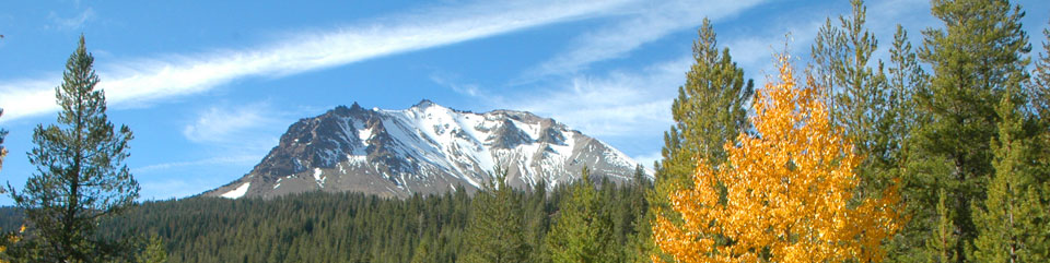
Lassen Peak's May 1914 eruption launched three years of sporadic volcanic outbursts. In the largest eruption, May 22, 1915, the peak blew a huge, mushroom-shaped cloud of ash over 30,000 feet into the air. The volcano's reawakening profoundly altered the surrounding area. Congress made this area a national park in 1916 because of the eruption and active volcanic landscape. Lassen Volcanic National Park is a valuable natural laboratory of volcanic events and associated hydrothermal features. The park lies at the southern end of the Cascade Range, which is a chain of active volcanoes that stretches north to Mount Garibaldi in British Columbia.
The western part of the park features great lava pinnacles, huge mountains created by lava flows, jagged craters, and steaming vents. The vents are rimmed by beautiful yellow sulfate crystals formed by hydrogen sulfide gases they emit. Cut by spectacular glaciated canyons, the area is dotted by lakes and threaded by clear rushing streams. At higher elevations snowfields can be found year-round. Spring and summer wildflowers adorn meadows. The eastern part of the park is a lava plateau over a mile above sea level, where you can find shield volcanoes and cinder cones. Forested with pine and fir, this area is studded with small lakes but boasts few streams. Warner Valley marks the southern edge of the Lassen plateau and features hydrothermal areas—Boiling Springs Lake, Devils Kitchen, and Terminal Geyser. This forested, steep glacial valley also has gorgeous meadows.
Lassen Volcanic National Park serves as a century-long example of how Mount St. Helens might recover from its eruptions in 1980. The Devastated Area shows the combined mud flow and avalanche destruction typical of Cascades volcanic eruptions. A different mechanism 350 years ago destroyed the Chaos Jumbles. A rock avalanche crashed down the Chaos Crags volcanic dome, to slam across the valley at 110-plus miles per hour with such force that it ran 400 feet up Table Mountain before losing momentum and surging back down across Manzanita Creek.
Lassen hydrothermal areas—Sulphur Works, Bumpass Hell (the largest). Little Hot Springs Valley, Boiling Springs Lake, Devils Kitchen, and Terminal Geyser—offer bubbling mud pots, steaming fumaroles, and boiling water. These thermal features undergo constant change—some are getting hotter and more acidic and others less so. To shed light on regional volcanic hazards, U.S. Geological Survey scientists along with National Park Service staff investigate and monitor the geologic variations.
Lassen and the Pacific Ring of Fire
Lassen Peak is one of many active, dormant, or extinct volcanoes found around the Pacific Ocean in a Ring of Fire. On this seismic zone, edges of plates that form Earth's crust grind against each other, and one plate subducts, sinks down.
Subduction creates molten rock, magma, at the plate margins. As the magma rises into the continental crust it becomes the feeding chambers of volcanoes.
Ancestral Brokeoff Volcano Some 400,000 to 600,000 years ago Brokeoff Volcano, a big composite volcano, built up through countless eruptions. Hydrothermal activity and weathering weakened and broke down the great volcano. Brokeoff Volcano's main vent probably stood above what is now Sulphur Works. The remnants of its flanks are Brokeoff Mountain, Mount Diller, Pilot Pinnacle, and Mount Conard. If you connect these peaks in a circle you can envision how big Brokeoff Volcano was—over eight miles wide at its base and at least 11,000 feet high.
Lassen Peak Lassen Peak formed 27,000 years ago as a volcanic vent on the northern flank of Brokeoff Volcano. It is one of the world's largest plug dome volcanoes, rising 2,000 feet to an elevation of 10,457 feet.
The Landscape Recovers
How does the landscape recover from volcanic episodes? That question revived as Mount St. Helens erupted in 1980, but the answer has been in process here for nearly a century—since Lassen Peak quieted down.
Important post-eruption plant succession sites in the park illustrate how, slowly yet relentlessly, plant life returns. The Devastated Area and Chaos Jumbles were initially revegetated to conifer forests without significant preparation by herbaceous plants. New forests in disturbed areas are more diverse than previous mature forests. Seeds carried from the higher elevations have brought species like hemlock and whitebark pine that are not usually found in this forest's normal succession.
The opportunity for trees to become established is great in earlier stages of species recovery and competition. At Chaos Jumbles competition will eventually crowd out four of eight coniferous species now found there.
The Devastated Area is now undergoing a successional process of revegetation, with herbs, grasses, shrubs, and trees. Lodgepole pines are generally the first trees to give way in time to other pines and firs. By contrast the Cinder Cone and Fantastic Lava Beds areas were slower to recover from eruptions in those areas in the mid-1600s.
Diversity abounds here because plant life mixes species from the Sierra Nevada to the south, the Cascade Range, and the Great Basin to the east. The park hosts nearly 800 plant species, whereas nearby Mount Shasta has only 485. In the park, 24 Sierran species occur at the northern limit of their range, and 14 Cascadian species are at their southern limit.
The forces that created the Devastated Area and Chaos Jumbles also created Hat and Manzanita lakes, fortuitous landscape recoveries for us today. Hat Lake has undergone succession too. As the basin fills with debris from higher elevations, the lake will disappear and become a meadow that will then eventually become a forest.
American Indians, Emigrants, and Historians
Atsugewi, Mountain Maidu, Yahi, and Yana Indian tribes have ancestral lands in this area. Because of deep snow, the high elevations, and seasonal deer migrations, they spent only warmer months here, for hunting, gathering, and spiritual activities.
They left few artifacts except stone points and knives. Ishi, last known Yahi Indian, appeared in Oroville, Calif., in 1911, having long avoided white settlers. He then lived at the University of California Museum in Berkeley, where he was an invaluable source of first-hand information for ethnologists.
Trapper Jedediah Smith traversed this area in 1828 on his overland trek to the West Coast. Euro-Americans began to settle here in the early 1840s. With California's 1848 Gold Rush, emigrants streamed into California.
Peter Lassen developed the Lassen Trail using the tall St. Joseph's Peak (Lassen Peak) to orient emigrants. Both the peak and park now bear his name. More successful was Nobles Emigrant Trail, that William Nobles developed in the 1850s. It took on regional transportation importance. Sections are still visible in the park. People tried mining, power development projects, ranching, and logging in the area. Early federal protection as a park saved it from heavy logging. Today this is one of the largest areas of old-growth forest in northern California.
B.F. Loomis documented Lassen Peak's eruption cycle and promoted the park's development. Loomis photographed the eruptions, explored geologically, and developed a large museum collection. The Loomis Museum, open summer and fall, is one of the park's information sites.
Visiting Lassen Volcanic
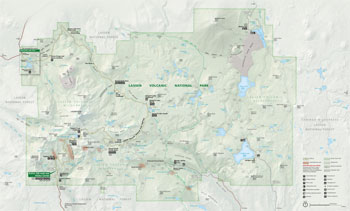 (click for larger map) |
Information The park newspaper and website list area accommodations, services, seasonal activities, and wheelchair-accessible facilities. Get your free newspaper at park information sites or contact the park. Buy maps and publications at information sites or from the nonprofit Lassen Association. Fees are charged at park entrances.
Accessibility We strive to make our facilities, services, and programs accessible to all. For details go to an information site, ask a ranger, call, or check our website.
Auto Tour The main road around three sides of Lassen Peak offers access to trails, lakes, and volcanic and hydrothermal features. The Road Guide to Lassen Volcanic National Park is sold at information sites. Speed limit is 35 mph or as posted. Do not stop on roadways; use the overlooks to view wildlife and scenery. Off-road vehicle travel is prohibited.
Campgrounds The eight park campgrounds are all above 5,650 feet elevation; ask your doctor about health problems at high altitudes. Reservations can be made and are required for group campsites. Call the park or see the website for more information. Camping at roadsides or in picnic areas and parking lots is prohibited except at the Southwest Walk-in Campground • Do not disturb any natural features. • Bears are present; store food properly. Do not feed wild animals. • Build fires only in campground fire grates; do not leave any fire unattended.
Hiking The 150 miles of park trails include 17 miles of Pacific Crest Trail. Self-guiding trails can introduce you to hiking. • Acclimate to high elevations gradually. Wear sturdy foot gear. • Avoid exposed areas in lightning storms. • Never hike alone. • Pets are not allowed on trails or boardwalks. • Stay on trails; take no shortcuts. • Bicycles, motor vehicles, and all wheeled conveyances are prohibited on trails. Ask a ranger about wheelchair use on trails. • Rock climbing is discouraged—volcanic rock is unstable. Talk to a ranger before climbing. • To safely drink backcountry surface water use an absolute 1-micron filter and then also boil the water for at least five minutes or treat it with iodine tablets.
Backcountry Use Free backcountry permits, required for any overnight backcountry stay, are issued for one trip at a time. Contact the park about closed areas. • Use self-contained stoves; wood fires are prohibited. • Pack out all trash. • Be avalanche-aware in winter: Always get weather and avalanche information before you enter park backcountry. Use may not be advised because of avalanche conditions.
Stock Use Pack and saddle stock may stay overnight only in the designated horse camps at Summit, Juniper, and Butte lakes—reservations required. Permits required for day use of stock.
Fishing and Boating Anglers need a California fishing license and must know park regulations and limits. Only non-power watercraft may be used on park lakes. Power boats (including those with electric motors) are prohibited. Boating is prohibited on Reflection, Emerald, Helen, and Boiling Springs lakes. US Coast Guard-approved personal flotation devices are required for each occupant of a watercraft. All boats must be removed nightly from Manzanita Lake and its lakeshore. Boat rentals are offered at Manzanita Lake Camper Store in summer.
Pets Pets must be leashed and are prohibited on trails and boardwalks, on lakeshores, in the backcountry, at evening talks, and in buildings.
Thermal Warnings: Boiling, acidic water may be on or near surfaces in thermal areas. Crusts over thermal features can be brittle; if you break through, you're in boiling water. Watch children closely. Stay on the boardwalks and established trails in thermal areas.
Weapons The use or display of weapons is prohibited. Weapons are not allowed in federal facilities. For firearms regulations check the park website or ask at an information site.
Source: NPS Brochure (2014)
|
Establishment
Wilderness — October 19, 1972 |
For More Information Please Visit The  OFFICIAL NPS WEBSITE |
Documents
A Comparison of Cinder Cones in the Crater Lake National Park Area With Those in the Lassen National Park Area (K.R. Cranson, June 7, 1967)
A Complex Magma Mixing Origin for Rocks Erupted in 1915, Lassen Peak, California (Michael A. Clynne, extract from Journal of Petrology, Vol. 40 No. 1, 1999, ©Oxford University Press)
A General Index to Lassen Nature Notes, 1932-1936 and Hawaii Nature Notes, 1931-1933 (Hazel Hunt Voth, 1938)
A Recent Volcano in Plumas County (H.W. Harkness, extract from Proceedings of the California Academy of Sciences, Vol. 5, 1874)
A Sight "Fearfully Grand" — Eruptions of Lassen Peak, California, 1914 to 1917 USGS Fact Sheet 2014-3119 (Michael A. Clynne, Robert L. Christiansen, Peter H. Stauffer, James W. Hendley II and Heather Bleick, December 2014)
Accessibility Self-Evaluation and Transition Plan Overview, Lassen Volcanic National Park, California (Draft, October 2020)
Acoustic Monitoring Report: Lassen Volcanic National Park NPS Natural Resource Report NPS/NRSS/NSNSD/NRR—2016/1306 (Ashley R. Pipkin, October 2016)
An Archaeological Survey of Lassen Volcanic National Park, California (Alfred E. Journey, 1974)
Analyses of Gas, Steam and Water Samples Collected in and Around Lassen Volcanic National Park, California, 1975-2002 U.S. Geological Survey Open-File Report 2010-1036 (Cathy J. Janik and Deborah Bergeld, 2010)
Analysis of Deer Browse Conditions and Ecological Relationships in Lassen Volcanic National Park (Gary B. Donart, 1968)
Bumpass Hell Trail Visitor Use Improvements Environmental Assessment (March 2018)
Chaos Crags Eruptions and Rockfall-Avalanches, Lassen Volcanic National Park, California (Dwight R. Crandell. Donal R. Mullineaux, Robert S. Sigafoos and Meyer Rubin, extract from Journal of Research of the U.S. Geological Survey, Vol. 2 No. 1, January-February 1974)
Chemical analyses of thermal and nonthermal springs in Lassen Volcanic National Park and vicinity, California USGS Open-File Report 83-311 (J.M. Thompson, 1983)
Cinder Cone National Monument (extract from Science, Vol. XXVI No. 654, July 12, 1907)
Comparison of Limnological Characteristics and Distribution and Abundance of Littoral Macroinvertebrates and Zooplankton in Fishbearing and Fishless Lakes of Lassen Volcanic National Park NPS Natural Resource Technical Report NPS/KLMN/NRTR—2008/116 (Michael S. Parker, August 2008)
Continuity and Change: A Photographic History of the Drakesbad Guest Ranch (HTML edition) (Tandy Bozeman, 2003, rev. 2017)
Cultural Landscape Report for Drakesbad Guest Ranch, Lassen Volcanic National Park (Amy Hoke and Len Warner, March 2005)
Cultural Landscapes Inventory: Drakesbad Guest Ranch, Lassen Volcanic National Park (2004, rev. 2009)
Cultural Landscapes Inventory: Lassen Volcanic National Park Highway, Lassen Volcanic National Park (2000)
Cultural Landscapes Inventory: Mineral Headquarters Historic District, Lassen Volcanic National Park (2004)
Distribution of introduced fishes and their effects on high elevation lake communities in Lassen Volcanic National Park, CA, USA (Michael S. Parker, Hartwell H. Welsh and Daniel Sarr, extract from Verhandlungen des Internationalen Verein Limnologie, Vol. 30 Part 9, January 2010)
Draft General Management Plan and Environmental Impact Statement, Lassen Volcanic National Park (August 2000)
Ecological Site Descriptions of Lassen Volcanic National Park, California (2011)
Eruption Probabilities for the Lassen Volcanic Center and Regional Volcanism, Northern California, and Probabilities for Large Explosive Eruptions in the Cascade Range USGS Scientific Investigations Report 2012-5176-B (Manuel Nathenson, Michael A. Clynne and L.J. Patrick Muffler, 2012)
Eruptions of Lassen Peak, California, 1914-1917 USGS Fact Sheet 173-98 (Michael A. Clynne, Robert L. Christiansen, Tracey J. Felger, Peter H. Stauffer and James W. Hendley II, 1999)
Exhibit Planning Report for the Loomis Museum at Lassen Volcanic National Park (Daniel Quan Design, January 1, 1989)
Fire History and Ecology, Lava Beds National Monument (Arlen H. Johnson and Garrett A. Smathers, from Tall Timbers Fire Ecology Conference Proceeding, Vol. 15, 1976)
Forest Structure and Residual Tree Growth at the Northwest Gateway Project Area, Lassen Volcanic National Park, California U.S. Geological Survey Open-File Report 2023-1021 (Micah C. Wright, Phillip J. van Mantgem and Calvin Farris, 2023)
Foundation Document, Lassen Volcanic National Park, California (December 2016)
Foundation Document Overview, Lassen Volcanic National Park, California (January 2016)
Fungi of Lassen Volcanic National Park Cooperative National Park Services Studies Unit Technical Report No. 21 (Wm. Bridge Cooke, November 1985)
General Management Plan/Environmental Impact Statement: Lassen Volcanic National Park, California (Final, January 1981)
General Management Plan: Lassen Volcanic National Park, California (July 2003)
Geologic Field-Trip Guide to Lassen Volcanic National Park and Vicinity, California USFS Scientific Investigations Report 2015-5067 (L.J. Patrick Muffler and Michael A. Clynne, 2015)
Geologic Resources Inventory Report, Lassen Volcanic National Park NPS Natural Resource Report NPS/NRPC/GRD/NRR-2014/755 (K. KellerLynn, January 2014)
Geology of the Lassen Peak District by Diller (J.S. Diller, 1889)
Geology of the Lassen Volcanic National Park, California (Howel Williams, extract from University of California Bulletin of the Department of Geological Sciences, Vol. 21 No. 8, 1932)
Historic American Engineering Record
Lassen Park Road (HAER No. CA-270)
Hot Spring Monitoring at Lassen Volcanic National Park, California 1983-1985 (Michael L. Sorey, extract from Proceedings of the Eleventh Workshop on Geothermal Reservoir Engineering, 1986)
"Hot Water" in Lassen Volcanic National Park — Fumaroles, Steaming Ground, and Boiling Mudpots USGS Fact Sheet 101-02 (Michael A. Clynne, Cathy J. Janik, and L.J.P. Muffler, 2003)
How Old is "Cinder Cone"? — Solving a Mystery in Lassen Volcanic National Park, California USGS Fact Sheet 023-00 (Michael A. Clynne, Duane E. Champion, Deborah A. Trimble, James W. Hendley II and Peter H. Stauffer, 2000)
Hydrothermal Alteration at Devil's Kitchen in the Lassen Volcanic National Park: A Mars Analogue (©Andy Wanta, Master's Thesis University of Wisconsin-Milwaukee, May 2018)
Impacts of Visitor Spending on the Local Economy: Lassen Volcanic National Park, 2012 NPS Natural Resource Report NPS/NRSS/EQD/NRR—2014/847 (Philip S. Cook, August 2014)
Integrated Aquatic Community and Water Quality Monitoring of Mountain Ponds and Lakes in the Klamath Network — Annual Data Report: 2013 results from Lassen Volcanic National Park, Crater Lake National Park, and Redwood National Park NPS Natural Resource Data Series NPS/KLMN/NRDS—2016/1055 (Eric C. Dinger, September 2016)
Integrated Aquatic Community and Water Quality Monitoring of Wadeable Streams in the Klamath Network — Annual Report: 2011 results from Whiskeytown National Recreation Area and Lassen Volcanic National Park NPS Natural Resource Technical Report NPS/KLMN/NRTR—2014/904 (Eric C. Dinger, and Daniel A. Sarr, August 2014)
Junior Ranger Activities Booklet, Lassen Volcanic National Park (2018; for reference purposes only)
Klamath Network Landbird Monitoring Annual Report: 2010 Results from Crater Lake National Park, Lassen Volcanic National Park, and Oregon Caves National Monument NPS Natural Resource Data Series NPS/KLMN/NRDS—2011//175 (Jaime L. Stephens, John D. Alexander and Sean R. Mohren, June 2011)
Klamath Network Landbird Monitoring Annual Report: 2012 results from Lassen Volcanic National Park, Oregon Caves National Monument, and Whiskeytown National Recreation Area NPS Natural Resource Data Series NPS/KLMN/NRDS—2013/536 (Jaime L. Stephens and Sean R. Mohren, August 2013)
Lahar Hazard Zones for Eruption-Generated Lahars in the Lassen Volcanic Center, California USGS Scientific Investigations Report 2012-5176-C (Joel E. Robinson and Michael A. Clynne, 2012)
Land Cover and Land Use Monitoring in the Klamath Network: 2016 Summary for Lassen Volcanic National Park NPS Natural Resource Report NPS/KLMN/NRR—2016/1308 (Jace Ives, Allison Snyder, Alice Chung-MacCoubrey, Jacob King, Lorin Groshong and Sean Mohren, September 2016)
Land Protection Plan, Lassen Volcanic National Park (1984, rev. 1988)
Landbird monitoring: 2015 Results from Lassen Volcanic National Park, Oregon Caves National Monument and Preserve, and Whiskeytown National Recreation Area NPS Natural Resource Data Series NPS/KLMN/NRDS-2016/1043 (Jaime L. Stephens, August 2016)
Lassen—A Page From History (Elisabeth L. Egenhoff, extract from Mineral Information Service, Vol. Vol. 23 No. 11, November 1970, ©California Department of Conservation)
"Lassen Glimpses": The Lassen Park Guide Book (1929)
Lassen Volcanic Guide: Post Dixie Fire (October 2021)
Lassen Volcanic National Park Historic Resources Study (Ann Emmons and Theodore Catton, June 2003)
Lassen Volcanic National Park Photograph Archives Project (January 2004 - March 2007) (Gina Rappaport, Date Unknown)
Lassen Volcanic National Park's Manzanita Lake: A Brief History (Douglas Hillman Strong, extract from The Pacific Historian, Vol. 15 No. 3, 1971)
Little Gem of the Cascades: An Administrative History of Lassen Volcanic National Park (Diane L. Krahe and Theodore Catton, University of Montana, September 2010)
Long-Range Interpretive Plan 2010-2019, Lassen Volcanic National Park (Edquist Davis Exhibits, March 2011)
Manzanita Lake (Lassen Volcanic National Park) Fisheries Management Plan Preliminary Draft (John M. Deinstadt, Glenn F. Sibbald and Al Denniston, January 1995)
Map: Cinder Cone National Monument (Date Unknown)
Measurements of Heat and Mass Flow from Thermal Areas in Lassen Volcanic National Park, California, 1984-93 USGS Water-Resources Investigations Report 94-4180-A (Michael L. Sorey and Elizabeth M. Colvard, 1994)
Measurements of Thermal-Water Discharge Outside Lassen Volcanic National Park, California, 1983-94 USGS Water-Resources Investigations Report 94-4180-B (Michael L. Sorey, Elizabeth M. Colvard and S.E. Ingebritsen, 1994)
Monitoring Vegetation Composition, Structure, and Function in Whiskeytown National Recreation Area and Lassen Volcanic National Park: Fiscal Year 2012 Annual Report NPS Natural Resource Data Series NPS/KLMN/NRDS-2014/628 (Sean B. Smith and Daniel Sarr, February 2013)
"Mount Lassen Is In Eruption And There Is No Mistake About That" (Mary R. Hill, extract from Mineral Information Service, Vol. 23 No. 11, November 1970, ©California Department of Conservation)
Museum Management Plan, Lassen Volcanic National Park (Kent Bush, Jonathan Bayless, Scott Isaacson, Lynn Marie Mitchell, James O'Barr and Brigid Sullivan-Lopez, 2000)
National Register of Historic Places Nomination Forms
Drakesbad Guest Ranch (Ann Emmons and Janene Caywood, November 2002)
Horseshoe Lake Ranger Station (Gordon Chappell, June 15, 1977)
Lassen Volcanic National Park Highway Historic District (Ann Emmons, Shaun Provencher and Len Warner, February 2004)
Lassen Volcanic National Park Multiple Property Listing (Ann Emmons, February 2004)
Loomis Visitor Center/Loomis Museum, Manzanita Lake Visitor Center/Manzanita Lake Museum (Gordon Chappell, October 21, 1974)
Manzanita Lake Naturalist's Services Historic District (Ann Emmons and Janene Caywood, February 2004)
Mount Harkness Fire Lookout and Pit Toilet Draft (Stephen R. Mark, March 1, 2010)
Nobles' Emigrant Trail HS-1 (Gordon S. Chappell, November 1974)
Park Headquarters (Gordon Chappell and Robert Cox, May 19 1978)
Prospect Peak Fire Lookout (Gordon Chappell, June 16, 1977)
The Sulphur Creek Archeological District (Kathleen Moffitt, April 2, 1976; Keith M. Anderson, rev. April 1979)
Summit Lake Ranger Station (Gordon Chappell, April 9, 1976)
Trails to Lassen Peak and Bumpass Hell: Lassen Volcanic National Park Highway Historic District (Boundary Increase) Draft (Stephen R. Mark, July 15, 2009)
Warner Valley Ranger Station (Gordon Chappell, April 22, 1976)
Natural Resource Condition Assessment, Lassen Volcanic National Park NPS Natural Resource Report NPS/NRSS/WRD/NRR-2013/725 (Paul R. Adamus, Dennis C. Odion, Gregory V. Jones, Lorin C. Groshong and Ryan Reid, November 2013)
Natural Resources Management Plan and Management Program: Lassen Volcanic (July 1979, rev. April 1984)
Newsletter (Lassen News/Lassen Park Foundation News; ©Lassen Park Foundation)
Fall 2005 • Summer 2006 • Fall 2006 • Summer 2007 • Summer 2008 • Fall 2008 • Fall 2009 • Fall 2010 • Summer 2011 • Fall 2011 • Summer 2012 • Spring 2013 • Fall 2013 • Winter 2016 • Summer 2016 • Sumer 2018 • Fall 2018 • Spring 2019 • Summer 2019 • Fall 2019 • Winter 2020 • Spring 2020 • Summer 2020 • Fall 2020 • Winter 2021 • Spring 2021 • Spring 2022
Park Newspaper (Peak Experiences)
Summer: 1986 • 1995 • 1999 • 2003 • 2005 • 2006 • 2008 • 2009 • 2010 • 2011 • 2012 • 2013 • 2014 • 2015 • 2016 • 2017 • 2018 • 2019 • 2020 • 2021 • 2022 • 2023
Winter: 2002-2003 • 2005-2006 • 2006-2007 • 2007-2008 • 2008-2009 • 2009-2010 • 2010-2011 • 2011-2012 • 2014-2015 • 2015-2016 • 2016-2017 • 2017-2018 • 2018-2019 • 2019-2020 • 2020-2021 • 2021-2022 • 2022-2023
Pika Monitoring, Upper Columbia Basin Network Inventory and Monitoring (undated)
Pika Monitoring at Crater Lake National Park, Craters of the Moon National Monument and Preserve, Lassen Volcanic National Park, and Lava Beds National Monument: 2010 Annual Monitoring Report (Mackenzie R. Jeffress, Lisa K. Garrett and Thomas J. Rodhouse, December 2010)
Pika Monitoring at Crater Lake National Park, Craters of the Moon National Monument and Preserve, Lassen Volcanic National Park, and Lava Beds National Monument: 2010-2014 Status Report NPS Natural Resource Data Series NPS/UCBN/NRDS-2015/782 (Thomas J. Rodhouse and Matthew Hovland, April 2015)
Pikas of Lassen Volcanic National Park: Project Summary and Results (January 2016)
Pleistocene Glaciation: Lassen Volcanic National Park (Phillip Kane, extract from California Geology, Vol. 35 No. 5, May 1982, ©California Department of Conservation)
Prescribed fire and fire suppression operations influence wildfire severity under server weather in Lassen Volcanic National Park, California, USA (Lucas B. Harris, Stacy A. Drury, Calvin A. Farris and Alan H. Taylor, extract from International Journal of Wildland Fire, Vol. 30 No. 7, 2021)
Principal facts for 382 gravity stations in Lassen Volcanic National Park and vicinity, California USGS Open-File Report 83-584 (Robert C. Jachens, D.R. Spydell and R.W. Saltus, 1983)
Proclamation: Cinder Cone National Monument (Theodore Roosevelt, May 6, 1907)
Quantitative analysis of the hydrothermal system in Lassen Volcanic National Park and Lassen Known Geothermal Resource Area USGS Water-Resources Investigations Report 84-4278 (M.L. Sorey and S.E. Ingebritsen, 1984)
Radiocarbon Dates from Volcanic Deposits of the Chaos Crags and Cinder Cone Eruptive Sequences and Other Deposits, Lassen Volcanic National Park and Vicinity, California U.S. Geological Survey Open-File Report 02-290 (Michael A. Clynne, Robert L. Christiansen, Deborah A. Trimble and John P. McGeehin, 2008)
Report on Sullys Hill Park, Casa Grande Ruin; the Muir Woods, Petrified Forest, and Other National Monuments, Including List of Bird Reserves: 1915 (HTML edition) (Secretary of the Interior, 1914)
Report on Wind Cave National Park, Sullys Hill Park, Casa Grande Ruin, Muir Woods, Petrified Forest, and Other National Monuments, Including List of Bird Reserves: 1913 (HTML edition) (Secretary of the Interior, 1914)
Restoration of Drakesbad Meadow, Lassen Volcanic National Park, California (David J. Cooper, 2002)
Restoration prioritization and procedures for Drakesbad Meadow, Lassen Volcanic National Park, California (David J. Cooper, Derek Schook and Evan Wolf, February 2012)
Review Report: Lassen Volcanic National Park-Caribou Wilderness Fire Management Plan (August 1984)
Rheologic Properties and Kinematics of Emplacement of the Chaos Jumbles Rockfall Avalanche, Lassen Volcanic National Park, California (Dean B. Eppler, Jonathan Fink and Raymond Fletcher, extract from Journal of Geophysical Research, Vol. 92 No. B5, April 10, 1987; ©American Geophysical Union)
Rock-art image in Fern Cave, Lava Beds National Monument, California: not the AD 1054 (Crab Nebula) supernova (R.A. Armitage, M. Hyman, J. Southon, C. Barat and M.W. Rowe, extract from Antiquity, v71, 1997)
Schlumberger soundings near Lassen Volcanic National Park, California USGS Open-File Report 89-670 (Adel A.R. Zohdy and Robert J. Bisdorf, 1989)
Simplified Geologic Map of Lassen Volcanic National Park (undated)
Small Vertebrate Inventory Project: Preliminary Results 2000-2004, Lassen Volcanic National Park (John D. Perrine, 2006)
Soil Survey of Lassen Volcanic National Park, California (2010)
Status of the Manzanita Lake Trout Fishery, Lassen Volcanic National Park (Alan Denniston, 1978)
Status of the Sierra Nevada: The Sierra Nevada Ecosystem Project
Status of the Sierra Nevada: The Sierra Nevada Ecosystem Project U.S. Geological Survey Digital Data Series DDS-43 (Don C. Erman, ed. and the SNEP Team, 1997)
Summary of the Sierra Nevada Ecosystem Project Report Wildland Resources Center Report No. 39/Sierra Nevada Ecosystem Project Final Report to Congress (SNEP Team, June 1996)
Volume I: Assessment Summaries and Management Strategies, Status of the Sierra Nevada Wildland Resources Center Report No. 36/Sierra Nevada Ecosystem Project Final Report to Congress (SNEP Team, June 1996)
Volume II: Assessments and Scientific Basis for Management Options, Status of the Sierra Nevada Wildland Resources Center Report No. 37/Sierra Nevada Ecosystem Project Final Report to Congress (SNEP Team, June 1996)
Volume III: Assessments, Commissioned Reports, and Background Information, Status of the Sierra Nevada Wildland Resources Center Report No. 38/Sierra Nevada Ecosystem Project Final Report to Congress (SNEP Team, June 1996)
Addendum, Status of the Sierra Nevada Wildland Resources Center Report No. 40/Sierra Nevada Ecosystem Project Final Report to Congress (SNEP Team, March 1997)
Lake Tahoe Case Study / Mediated Settlement Agreement for Sequoia National Forest, Section B. Giant Sequoia Grovers Master Bibliography U.S. Geological Survey Digital Data Series DDS-43 (Don C. Erman, ed. and the SNEP Team, 1997)
Status of the Trophy Rainbow Trout Fishery at Manzanita Lake (Lassen Volcanic National Park) Based on Reports from Angler Survey Boxes iin 1994 (John M. Deinstadt and Al Denniston, January 1995)
Status of White Pines Across Five Western National Park Units: Initial Assessment of Stand Structure and Condition NPS Natural Resource Report NPS/KLMN/NRR—2021/2232 (Matthew J. Reilly, Jonathan C. B. Nesmith, Sean B. Smith, Devin S. Stucki and Erik S. Jules, February 2021)
Summary of 1976 Lake Survey Data Relating to the Status of Trout Fisheries in Lassen Volcanic National Park (Alan Denniston, February 1977)
Susceptibility to Mudflows in the Vicinity of Lassen Peak, California United States Geological Survey Water-Supply Paper 2310 (Donna C. Marron and Julie A. Laudon, extract from Selected Papers in Hydrologic Sciences 1986, December 1986)
Teleseismic residual study of the Lassen Volcanic National Park region in California USGS Open-File Report 86-252 (P.A. Berge and M.E. Monfort, 1986)
The Birds of Lassen Volcanic National Park: An annotated checklist (Ryan D. Burnett and Jon R. King, 2004)
The Lookout on Mount Lassen (William C. Hodge, extract from American Forests, Vol. 20, August 1914)
The Source of the Heat and the Source of the Water in the Hot Springs of the Lassen National Park (Arthur L. Day, and E. T. Allen, extract from The Journal of Geology, Vol. 32 No. 3, April-May 1924)
The Volcanic Activity and Hot Springs of Lassen Peak (Arthur L. Day and E.T. Allen, 1925)
The Volcanic Activity of Lassen Peak, California (Ruliff S. Holway, extract from The Popular Science Monthly, Vol. LXXXVI, March 1915)
The Volcanic History of Lassen Peak, Lassen Volcanic National Park, California (J.S. Diller, 1918)
Vegetation Community Monitoring: 2015 Results From Whiskeytown National Recreation Area and Lassen Volcanic National Park NPS Natural Resource Data Series NPS/KLMN/NRDS—2016/1051 (Sean B. Smith, August 2016)
Vegetation Management Plan for Lost Creek and Crags Campgrounds, Lassen Volcanic National Park (2002)
Vertebrate Natural History of a Section of Northern California Through the Lassen Peak Region University of California Publications in Zoology Vol. 35 (Joseph Grinnell, Joseph Dixon and Jean M. Linsdale, October 1930)
Volcano Hazards Assessment for the Lassen Region, Northern California USGS Scientific Investigations Report 2012-5176-A (Michael A. Clynne, Joel E. Robinson, Manuel Nathenson and L.J. Patrick Muffler, 2012)
Volcano Hazards of the Lassen Volcanic National Park Area, California USGS Fact Sheet 022-00 (Michael A. Clynne, Robert L. Christiansen, C. Dan Miller, Peter H. Stauffer and James W. Hendley II, 2000)
Wadeable Streams Monitoring: 2014 results from Whiskeytown National Recreation Area and Lassen Volcanic National Park NPS Natural Resource Report NPS/KLMN/NRR—2017/1536 (Eric C. Dinger, October 2017)
Warner Valley Comprehensive Site Plan Final Environmental Impact Statement (September 2010)
Weed Management Plan and Environmental Assessment, Lassen Volcanic National Park (March 2008)
Wetlands of Lassen Volcanic National Park: An Assessment of Vegetation, Ecological Services, and Condition NPS Natural Resource Technical Report NPS/KLMN/NRTR-2008/113 (Paul R. Adamus and Cheryl L. Bartlett, March 2008)
Whitebark Pine in Crater Lake and Lassen Volcanic National Parks: Initial Assessment of Stand Structure and Condition NPS Natural Resource Report NPS/KLMN/NRR—2017/1459 (Erik S. Jules, Jenell I. Jackson, Sean B. Smith, Jonathan C. B. Nesmith, Leigh Ann Starcevich and Daniel A. Sarr, June 2017)
Whitebark Pine Monitoring: 2015 results from Crater Lake National Park and Lassen Volcanic National Park NPS Natural Resource Report NPS/KLMN/NRR—2016/1319 (Sean B. Smith and Alice Chung-MacCoubrey, October 2016)
Whitebark Pine Monitoring: 2016 results from Crater Lake National Park and Lassen Volcanic National Park NPS Natural Resource Report NPS/KLMN/NRR—2017/1484 (Sean B. Smith, July 2017)
Whitebark Pine Monitoring at Crater Lake and Lassen Volcanic National Parks: Fiscal Years 2012–2014 Project Report NPS Natural Resource Report NPS/KLMN/NRR—2015/1052 (Jenell Jackson, Erik S. Jules, Sean B. Smith, E. April Sahara and Daniel A. Sarr, October 2015)
Wildland Fire Management Plan, Lassen Volcanic National Park (April 2012)
Wildland Fire Management Plan, Lassen Volcanic National Park (May 2022)
Wildland Fire Use Risk Assessment in Lassen Volcanic National Park (Mike Lewelling, March 2006)
lavo/index.htm
Last Updated: 01-Jan-2025